A mesmerizing video captured by a drone flying over an erupting volcano in Iceland shows the moment when the UAV gets too close to the action and winds up being devoured by lava. The amazing piece of footage was reportedly captured last week by photographer Joey Helms as he was filming the ongoing eruption of Iceland’s Fagradalsfjall volcano. Over the last few months, the site has become something of a proverbial hot spot for drone operators looking to capture amazing footage. This particular flight, however, provided a previously unseen and rather destructive perspective.
Flying over a river of lava, Helms’ drone eventually hovers atop the volcano’s central crater as massive plumes of lava are ejected into the air. Suddenly, the UAV begins to sound as if it is in distress and then it is quickly devoured by the molten rock. Explaining what caused the downfall of his drone, Helms said that “around the volcano where you have the hot gases emitted they cause turbulences all around it and hot rocks raining on to you, flying these things is even more tricky.” While the daring flight may have cost him his drone, it did provide the photographer with what we presume he hopes will be a one-of-a-kind piece of footage.
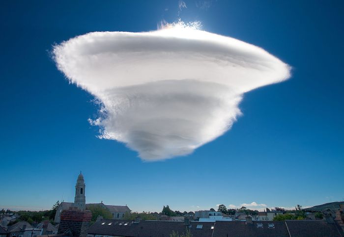
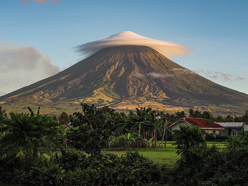
Lenticular clouds (Altocumulus lenticularis in Latin) are stationary clouds that form in the troposphere, typically in perpendicular alignment to the wind direction. They are often comparable in appearance to a lens or saucer.
There are three main types of lenticular clouds: altocumulus standing lenticular (ACSL), stratocumulus standing lenticular (SCSL), and cirrocumulus standing lenticular (CCSL), varying in altitude above the ground. Because of their unique appearance, they have been suggested as an explanation for some unidentified flying object (UFO) sightings.
An amazing piece of security camera footage from a high school in Wisconsin shows a lightning strike shattering a sizeable tree in seconds. According to a local media report, the jaw-dropping event occurred during a storm on Thursday morning in the city of Wautoma. As students were preparing to take a test, they were shaken from their studies by a monstrous thunder clap seemingly coming from right outside the school. The discovery of a downed tree near the building and a subsequent check of the security camera footage led them to find the stunning scene that had been captured on film.
In the video, a monstrous lightning bolt can be seen striking the top of the tree, causing it to briefly illuminated by fire. Seconds later, the entire tree crumbles to the ground in an instant, leaving behind only a pile of destroyed timber and broken branches. Reflecting on the remarkable moment wherein their school day took a dramatic turn, Wautoma high school principal Jennifer Johnson said, “initially, the students and staff were startled by the event; however, after realizing what had just happened, they were fascinated by the rare incident that occurred just feet from them.”
Photographer and scientist Nathan Myhrvold has developed a camera that captures snowflakes at a microscopic level never seen before
“Yellowknife Flurry,” a photograph by Nathan Myhrvold, captures the intricate structure of snowflakes. (Nathan Myhrvold / Modernist Cuisine Gallery, LLC)
The first chill of a winter storm is enough to send most people indoors, but not Nathan Myhrvold. The colder the weather, the better his chances are of capturing a microscopic photograph of a snowflake. Now, nearly two years in the making, Myhrvold has developed what he bills as the “highest resolution snowflake camera in the world.” Recently, he released a series of images taken using his creation, a prototype that captures snowflakes at a microscopic level never seen before.
Myhrvold, who holds a PhD in theoretical mathematics and physics from Princeton University and served as the Chief Technology Officer at Microsoft for 14 years, leaned on his background as a scientist to create the camera. He also tapped into his experience as a photographer, most notably as the founder of Modernist Cuisine, a food innovation lab known for its high-resolution photographs of various food stuffs published into a five-volume book of photography of the same name that focuses on the art and science of cooking. Myhrvold first got the idea to photograph snowflakes 15 years ago after meeting Kenneth Libbrecht, a California Institute of Technology professor who happened to be studying the physics of snowflakes.
“In the back of my mind, I thought I’d really like to take snowflake pictures,” Myhrvold says. “About two years ago, I thought it was a good time and decided to put together a state-of-the-art snowflake photography system…but it was a lot harder than I thought.”
Photographing snowflakes is nothing new. In the late 1880s, a Vermont farmer by the name of Wilson Bentley began shooting snowflakes at a microscopic level on his farm. Today he’s considered a pioneer for his work, which is part of the Smithsonian Institution Archives. His photography is considered the inspiration for the common wisdom that “no two snowflakes are alike.”
More than a century later, the field of snowflake photography has continued to evolve by leaps and bounds, which is evident in the high-res images that Myhrvold has produced with his own camera.
In simple terms, the system Myhrvold developed is comprised of one part microscope and one part camera, but with a number of parts that work in tandem to complete the arduous task of capturing an image of a snowflake, a subject that’s not only miniscule (most snowflakes measure less than a half-inch in diameter) but also quick to melt. In fact, a snowflake’s tendency to disintegrate was one of the biggest challenges Myhrvold had to overcome with this project. His solution: equipping his 50-pound camera system with a thermoelectric cooling system, a carbon fiber frame and LED lights, which give off less heat than standard lights. Every single part of his Frankenstein-esque device, which stands at about five feet in height off the ground when placed on a table, was built using materials that are less likely to cause melting or sublimation of the subject matter.
“Light could melt the snowflake, so I found a company in Japan that makes LED lights for industrial purposes,” he says. “My camera’s flash is one-millionth of a second and a thousand times faster than that of a typical camera flash.”
Obviously, some locales are better suited for snowflake photography than others. For example, snowflakes in the Pacific Northwest, where Myhrvold is based, aren’t nearly cold enough and either melt or sublimate (when ice turns to gas) too quickly, while on the East Coast, they’re too wet due to the humidity in the air, which can cause snowflakes to stick together. So, he ventured to an even higher latitude with perfect conditions—Timmins, a town in northeastern Ontario, Canada.
“Somewhere between negative 15 degrees and negative 20 degrees Fahrenheit is the snowflake-shooting sweet spot,” he says.
“No Two Alike,” by Nathan Myhrvold (Nathan Myhrvold / Modernist Cuisine Gallery, LLC)
Myhrvold also had to figure out how to physically capture a snowflake. (It’s not quite as simple as hoping that the perfect snowflake just so happens to fall into your mittened hand.) He quickly learned that catching them on a glass microscope slide wouldn’t work; glass is a known insulator. But an artificial sapphire slide, made of the same crystal material as one would find in a high-end watch, had a lower thermal conductivity ratio than glass, making it the perfect material to gather specimens.
A close-up look at the snowflake camera. (Modernist Cuisine Gallery, LLC)
Myhrvold adds that it’s taken a lot of “trial and error” to get his project to the point where it is now. And even now, he’s still tinkering with different elements to add to his snowflake photography system.
In the last few years, news of unexpected sinkholes swallowing cars, houses and people have made headlines with disturbingly high frequency. These reports are mainly coming from Florida, the U.S., where almost the entire state is karst terrain (made of limestone), which means it has the potential for sinkholes. Mexico, Belize and parts of Italy and China are also karst area, but the phenomenon of sinkholes suddenly appearing in apparently stable grounds is mostly American. Experts estimate thousands of sinkholes form every year in Florida alone.
Sinkholes form when water flowing underground has dissolved rock, mostly limestone and sometimes clay, below the surface, leading to the formation of underground voids. When the surface layer can no longer take the weight of whatever that’s above, it collapses into the void forming sinkholes. These sinkholes can be dramatic, because the surface land usually stays intact until there is not enough support. Then, a sudden collapse of the land surface can occur.
A giant sinkhole caused by the rains of Tropical Storm Agatha is seen in Guatemala City on May 31, 2010. More than 94,000 people were evacuated as the storm buried homes under mud, swept away a highway bridge near Guatemala City and opened up sinkholes in the capital. (Casa Presidencial / Handout / Reuters)
An aerial view of the damaged Gran Marical de Ayacucho highway in the state of Miranda outside Caracas December 1, 2010. Thousands of Venezuelans fled their homes after landslides and swollen rivers killed at least 21 people and threatened to cause more damage. (Photo by Miranda Government/Reuters)
A construction vehicle lies where it was swallowed by a sinkhole on Saint-Catherine Street in downtown Montreal, August 5, 2013. (Photo by Christinne Muschi/Reuters)
Pamela Knox waits for rescue after a massive sinkhole opened up underneath her car in Toledo, Ohio in this July 3, 2013 handout photo provided by Toledo Fire and Rescue. Toledo firefighters later rescued Knox without major injuries. Fire officials told a local TV station that a water main break caused the large hole. Picture taken July 3, 2013. (Photo by Lt. Matthew Hertzfeld/Toledo Fire and Rescue/Handout via Reuters)
A stranded car is hoisted from a collapsed road surface in Guangzhou, Guangdong province, September 7, 2008. The road collapsed on Sunday afternoon and trapped the car in a hole, which measured 5 meters (16.4 feet) in depth and 15 meters (49.2 feet) in diameter, local media reported. Further investigation is underway. Picture taken September 7, 2008. (Photo by Reuters/China Daily)
An aerial view shows the debris of a residential building and a destroyed road in the village of Nachterstedt, July 18, 2009. Three residents were missing in the eastern German village of Nachterstedt after their lakeside home and another building suddenly collapsed early Saturday into the water. A 350-metre stretch of shoreline gave way next to an old open-cast coalmine converted to a lake, about 170 kilometres south-west of Berlin. (Photo by Reuters/Gemeindeverwaltung Nachterstedt)
Rescue workers remove a bus with a crane from a Lisbon street hole November 25, 2003. The bus was parked on a Lisbon street when the ground began to open up and gobble it. No casualties were reported. (Photo by Jose Manuel/Reuters)
A truck is seen in a hole after part of the structure of a bridge collapsed into a river in Changchun, Jilin province May 29, 2011. Two truck passengers were injured, while the cause of the accident is still under investigation, local media reported. (Photo by Reuters/China Daily)
Cars lie in a sinkhole, caused when a road collapsed into an underground cave system, in the southern Italian town of Gallipoli March 30, 2007. There were no injuries in the overnight incident, according to local police. (Photo by Fabio Serino/Reuters)
A giant sinkhole that swallowed several homes is seen in Guatemala City February 23, 2007. At least three people have been confirmed missing, officials said. (Photo by Reuters/Stringer)
A large sinkhole opened on East Monument Street in Baltimore in summer 2012. The sinkhole appeared above a 120-year-old drainage culvert after heavy rains, causing evacuations and closing the road. (Algerina Perna/Baltimore Sun Photo)
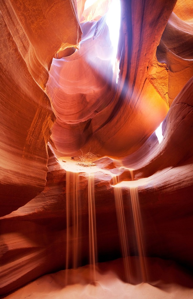
Antelope Canyon is a slot canyon (vary narrow canyon) in the American Southwest. It is located on Navajo land east of Page, Arizona. Antelope Canyon includes two separate, photogenic slot canyon sections, referred to individually as Upper Antelope Canyon or The Crack; and Antelope Canyon or The Corkscrew.
The Navajo name for Upper Antelope Canyon is Tsé bighánílíní, which means “the place where water runs through rocks.” Lower Antelope Canyon is Hazdistazí (advertised as “Hasdestwazi” by the Navajo Parks and Recreation Department), or “spiral rock arches.” Both are located within the LeChee Chapter of the Navajo Nation.
Antelope Canyon was formed by erosion of Navajo Sandstone, primarily due to flash flooding and secondarily due to other sub-aerial processes. Rainwater, especially during monsoon season, runs into the extensive basin above the slot canyon sections, picking up speed and sand as it rushes into the narrow passageways. Over time the passageways eroded away, making the corridors deeper and smoothing hard edges in such a way as to form characteristic ‘flowing’ shapes in the rock.
Flooding in the canyon still occurs. A flood occurred on October 30, 2006, that lasted 36 hours, and caused the Tribal Park Authorities to close Lower Antelope Canyon for five months.
Antelope Canyon is visited exclusively through guided tours, in part because rains during monsoon season can quickly flood the canyon. Rain does not have to fall on or near the Antelope Canyon slots for flash floods to whip through, as rain falling dozens of miles away ‘upstream’ of the canyons can funnel into them with little prior notice. On August 12, 1997, eleven tourists, including seven from France, one from the United Kingdom, one from Sweden and two from the United States, were killed in Lower Antelope Canyon by a flash flood. Very little rain fell at the site that day, but an earlier thunderstorm had dumped a large amount of water into the canyon basin, 7 miles (11 km) upstream. The lone survivor of the flood was tour guide Francisco “Poncho” Quintana, who had prior swift-water training. At the time, the ladder system consisted of amateur-built wood ladders that were swept away by the flash flood. Today, ladder systems have been bolted in place, and deployable cargo nets are installed at the top of the canyon. At the fee booth, a NOAA Weather Radio from the National Weather Service and an alarm horn are stationed.
Despite improved warning and safety systems, the risks of injuries from flash floods still exist. On July 30, 2010, several tourists were stranded on a ledge when two flash floods occurred at the Upper Antelope Canyon. Some of them were rescued and some had to wait for the flood waters to recede. There were reports that a woman and her 9-year-old son were injured as they were washed away downstream, but no fatalities were reported.


/https://public-media.si-cdn.com/filer/9d/06/9d066b9a-1cf0-4ff8-8782-cd375713101b/yellowknife-flurry.jpg)


 A close-up look at the snowflake camera.