South-central Manitoba.
Energy
Ripple Rock Big Blast
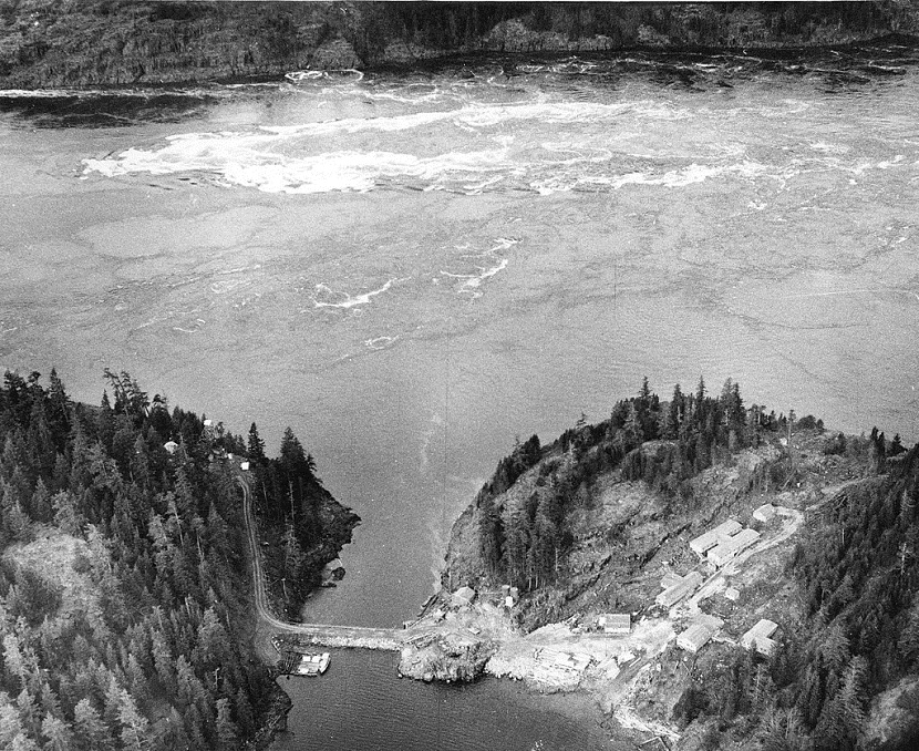
Ripple Rock is an underwater mountain located in the Seymour Narrows of the Discovery Passage in British Columbia, Canada. It had two peaks (2.74 metres and 6.4 metres below the surface at low tide) that produced large, dangerous eddies from the strong tidal currents that flowed around them at low tide. Ships transiting the strait preferred to wait until slack tide in order to safely bypass the rock.
The hazardous nature of the rock prompted the Canadian government to remove the top of the mountain in a controlled explosion on 5 April 1958. The event was one of the first live coast-to-coast television broadcasts of an event in Canada and was designated a National Historic Event of Canada.

The rock was first noted by explorer George Vancouver in 1791, describing it as “one of the vilest stretches of water in the world”.
The first known large ship to fall prey to Ripple Rock was the sidewheel steamer Saranac in 1875, as it was heading north to Alaska. At least 20 large and 100 smaller vessels were badly damaged or sunk between then and 1958. At least 110 people drowned in these accidents.
In the 1860s a plan was started to link Vancouver Island to the mainland at Bute Inlet, using Ripple Rock as a mid-support for the bridge. This plan continued through the years, and caused political opposition to destroying Ripple Rock, until it was decided to destroy the rock to improve safety for mariners.
As early as 1931, a marine commission recommended removing Ripple Rock, but it was not until 1942 that the government authorized attempts to remove it and issued the first contract to do so.
In 1953, the National Research Council of Canada commissioned a feasibility study on the idea of planting a large explosive charge underneath the peaks by drilling vertical and horizontal shafts from Maude Island in the sound. Based on the study, this approach was recommended. Dolmage and Mason Consulting Engineers were retained to plan the project, and three firms, Northern Construction Company, J.W. Stewart Limited and Boyles Brothers Drilling Company, were granted the contract, which cost in excess of 3 million Canadian dollars (equivalent to $28,585,714 CAD in 2018).
Although not planned as a test for nuclear weapons purposes, this large underground explosion at Ripple Rock was of interest to nuclear weapons scientists at the United Kingdom’s Atomic Weapons Research Establishment at Aldermaston, which sent a delegation to Canada and set up various monitoring instruments to record data from the explosion. Little more is known of their objectives, although there are detailed accounts in two declassified documents in the National Archives in London.
Between November 1955 and April 1958, a three-shift operation involving an average of 75 men worked to build 150 metres (500 ft) of vertical shaft from Maude Island, 720 metres (2,370 ft) of horizontal shaft to the base of Ripple Rock, and two main vertical shafts up into the twin peaks, from which “coyote” shafts were drilled for the explosives. The contract was awarded to two firms for $2,639,000. At the time of the contract it was estimated the tunnels and shafts would not be completed until either 1957 or 1958. 1,270 metric tonnes of Nitramex 2H explosive was placed in these shafts, estimated at ten times the amount needed for a similar explosion above water.
The explosion took place at 9:31:02 am on 5 April 1958. 635,000 metric tons of rock and water were displaced by the explosion, spewing debris at least 300 metres in the air which fell on land on either side of the narrows. The blast increased the clearing at low tide to about 14 metres (45 feet). After this, its two peaks were 13.7 m (45 ft) and 15.2 m (50 ft) underwater.
The Royal Canadian Mounted Police had cleared the area of people within 5 kilometres (3 mi) of the explosion, and the engineers and TV crew that witnessed the explosion were housed in a bunker.
The explosion was noted as one of the largest non-nuclear planned explosions on record, though Soviet authorities reported a larger explosion in the Ural Mountains to carve a new channel for the Kolonga River and in China to open a copper mine.

Possible gasoline shortage in eastern U.S. after hacked pipeline had to shut down
The pipeline is back up and running. But people always overreact.
How to create a shortage: 1) spread panic; 2) start hoarding;

This one really takes the cake…

Not only is he selfish and entitled, that’s also quite illegal.
I can’t believe people are really stupid enough to fill plastic bags with gasoline.

The Falkland Islands are popular again. Since the discovery of massive offshore oil reserves.
Interesting how oil dictates geopolitical relations. Governments and corporations are obssessed with finding and then pumping oil. Seemingly unimportant areas of the world that were once regarded as no more than boondock hinterlands, become the life of the party when oil is discovered under them. Such is the case with the Falkland Islands.

The Falkland Islands ( Spanish: Islas Malvinas) are an archipelago located in the South Atlantic Ocean on the Patagonian Shelf. The principal islands are about 310 miles (500 kilometres) east of the Patagonian coast at a latitude of about 52°S. The archipelago which has an area of 4,700 square miles (12,173 square kilometres) comprises East Falkland, West Falkland and 776 smaller islands. The islands, a British Overseas Territory, enjoy a large degree of internal self-government, with the United Kingdom guaranteeing good government and taking responsibility for their defence and foreign affairs. The capital is Stanley on East Falkland.
Controversy exists over the Falklands’ original discovery and subsequent colonisation by Europeans. At various times there have been French, British, Spanish, and Argentine settlements. Britain re-established its rule in 1833, though the islands continue to be claimed by Argentina. In 1982, following Argentina’s invasion of the islands, the two-month-long undeclared Falklands War between both countries resulted in the surrender of all Argentine forces and the return of the islands to British administration.
The population, estimated at 2,841, primarily consists of native Falkland Islanders, the vast majority being of British descent. Other ethnicities include French, Gibraltarian, and Scandinavian. Immigration from the United Kingdom, Saint Helena, and Chile has reversed a former population decline. The predominant and official language is English. Under the British Nationality Act of 1983, Falkland Islanders are legally British citizens.

On 2 April 1982, Argentina invaded the Falkland Islands and other British territories in the South Atlantic. By exploiting the long-standing feelings of Argentines towards the islands, the nation’s ruling military junta sought to divert public attention from Argentina’s poor economic performance and growing internal opposition. The United Kingdom’s reduction of military capacity in the South Atlantic is considered to have encouraged the invasion.
The United Kingdom sent an expeditionary force to retake the islands. After short but fierce naval and air battles, the British forces landed at San Carlos Water on 21 May, and a land campaign followed leading to the British taking the high ground surrounding Stanley on 11 June. The Argentine forces surrendered on 14 June 1982. The war resulted in the deaths of 255 British and 649 Argentine soldiers, sailors and airmen, as well as 3 civilian Falklanders.

The United Kingdom and Argentina both claim responsibility for the Falkland Islands. The UK bases its position on continuous administration of the islands since 1833 (apart from 1982) and the islanders having a “right to self determination, including their right to remain British if that is their wish”. Argentina posits that it gained the Falkland Islands from Spain, upon becoming independent from it in 1816, and that the UK illegally occupied them in 1833.
Diplomatic relations between the United Kingdom and Argentina, which were severed at the outbreak of the Falklands War in 1982, were re-established in 1990. In 2007, Argentina reasserted its claim over the Falkland Islands, asking for the UK to resume talks on sovereignty. In 2009, British prime minister Gordon Brown met with Argentine president Cristina Fernández de Kirchner and declared that there would be no talks over the future sovereignty of the Falkland Islands. As far as the United Kingdom and the Falkland Islands are concerned, no pending issue to resolve exists.
Argentina seems to have gotten very interested in the Islands again since the discovery of oil reserves offshore near the Islands.
A 1995 agreement between the UK and Argentina had set the terms for exploitation of offshore resources including oil reserves as geological surveys had shown there might be up to 60 billion barrels (9.5 billion cubic metres) of oil under the seabed surrounding the islands. However, in 2007 Argentina unilaterally withdrew from the agreement; Falklands Oil and Gas Limited then signed an agreement with BHP Billiton to investigate the potential exploitation of oil reserves. Due to the difficult climatic conditions of the southern seas exploitation will be difficult, though economically viable; the continuing sovereignty dispute with Argentina is also hampering progress.
Falkland Islands Economic Zone

In February 2010 exploratory drilling for oil was begun by Desire Petroleum, but the results from the first test well were disappointing. Two months later, on 6 May 2010, Rockhopper Exploration announced that “it may have struck oil”. Subsequent tests showed it to be a commercially viable find; an appraisal project was launched and on 14 September 2011.
Not sheep farms and penguin populated backwaters anymore.

Village of Goose Green

Action Packed Heineken Beer Commercial
Included a cameo by Tattoo from fantasy Island fame.

Proposed Cool Power Transmission Towers

They haven’t been built yet, but there are plans to get the structures up in the next few years.
California’s Secret Oil Islands
Not too far off the coast of Long Beach, California, are a set of four artificial islands containing towering white buildings set amidst palm trees and shrubs and waterfalls, all dramatically lit by colorful lights at night. From the nearby shore, the man-made islands appear to be occupied by some sort of high priced condos or resorts. But truth is—they are just a façade camouflaging huge oil-drilling operations in the bay.
Disguising industrial infrastructures so that they blend with the environment is nothing new. The city of Toronto has been dressing up electric substations into quiet little houses for more than a century. Similarly, cities such as New York, Paris and London hide ventilation shafts and railway tracks behind phony walls and faux buildings. These fakeries are rarely advertised, instead left to be discovered by curious citizens.
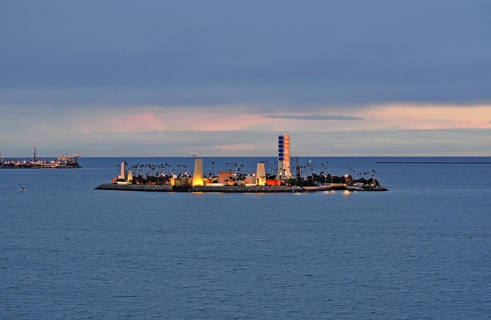
The building of Long Beach’s THUMS Islands, however, was a much publicized project.
THUMS stands for Texaco, Humble (now Exxon), Union Oil, Mobil, and Shell—the five companies that formed a consortium to oversee drilling operations in the San Pedro Bay. The islands were built in 1965 at an estimated cost of $22 million. More than 640,000 tons of boulders, some as large as five tons each, were brought from Catalina Island and used to build the perimeters of the islands, starting from the floor of the harbor, some 30-40 meters deep. The islands were then filled with sand dredged from the bottom of the harbor floor. The next step was landscaping and equipment installation.
When Long Beach voters gave the go-ahead to the ambitious plan of tapping into the oil resources located offshore, part of the arrangement was that the islands should be designed to appear as tropical settings and that they should hide the actual drilling operations.
“The islands were required to blend in with the local landscape and scenery. The guiding principle was that the islands were to enhance, rather than detract from, the harbor’s natural beauty,” said Frank Komin, executive vice president of southern operations for California Resources Corporation, the company that currently owns the islands.
The islands were designed by Joseph Linesch, who also helped design landscaping at Disneyland. Palm trees were planted on the exterior. Concrete facades that hide the derricks also served the purpose of bouncing industrial noise away from the residents living nearby.
The THUMS Islands are also known as the Astronaut Islands, having been renamed in honor of four American astronauts who lost their lives in the service of NASA—Theodore C. Freeman, Gus Grissom, Ed White and Roger B. Chaffee. The latter three were Apollo 1 astronauts who had perished in a fire accident at the launch pad.


The island on the right is Island Grissom, one of the THUMS offshore oil platforms.
The Reflecting Rays of Solar Power Towers
In a patchwork of agricultural fields outside Seville, Spain, two giant 40-storey-high concrete towers rise. The obelisk-like structures are surrounded by an immense array of mirrors that reflect sunlight, bathing the top of the towers with a blinding white light. The rays of sunlight reflected by hundreds of huge mirrors are so intense that they illuminate the water vapor and dust hanging in the air creating visible beams. The otherworldly spectacle is the world’s first commercially operating power station using the Sun’s thermal energy to produce steam, which is used to power turbines to generate electricity.
The plant’s operator, Abengoa Solar, claims that it generates 11 Megawatts (MW) of electricity without emitting a single puff of greenhouse gas. The solar power plant, currently powers 60,000 homes, but when the project is completed sometime around this year, the plant should generate enough power to service 180,000 homes. The final project, which will be able to produce over 300MW, will include a series of towers, two more of which are being built, and standard photovoltaic power plants, as well as a mixture of newer parabolic solar collectors which will be installed at a later stage.

The power plant consist of two towers – PS10 and PS20. PS10 is surrounded by 624 heliostats – huge mirrors that track the sun throughout the year, reflecting the sun’s rays to the top of the tower where a solar receiver and a steam turbine are located. The PS20 plant is even larger with 1,255 heliostats and will produce up to 20 megawatts when fully operational in 2013. The towers together will prevent emissions of more than 600,000 tones of carbon dioxide into the atmosphere per year over its 25-year life.
The solar plant is supported by a 1.2 MW Sevilla PV plant composed of 154 silicon plate heliostats that produce electricity from solar radiation. The plant can generate 2.1GWh of clean energy annually. The remaining power plants, which will be built over the next few years, will include low- and high-concentration photovoltaic, tower thermoelectric, parabolic-trough collector and Stirling dish plants.
Although power from the plant will initially be more expensive than from conventional sources, prices will fall as the technologies develop.
Solar power plant producing electricity this way are being constructed elsewhere around the world. An even larger plant, Gemasolar Thermosolar Plant, also is Seville Spain operates with 2650 heliostats and produces 19.9 MW of electricity. Gemasolar is the worlds’ first solar power plant capable of delivering power round the clock.


The towers are 571 feet tall (174 m)


Two newer solar power tower facilities have come online in the United States that make the Seville power facility look small.
| Power plants | Installed capacity (MW) | Yearly production (GWh) | Country | Developer/Owner | Completed |
|---|---|---|---|---|---|
| Ivanpah Solar Power Facility | 392 (U/C) | 420 | United States | BrightSource Energy | 2013 |
| Crescent Dunes Solar Energy Project | 110 (U/C) | 500 | United States | SolarReserve | 2013 |
| PS20 solar power tower | 20 | 44 | Spain | Abengoa | 2009 |
| Gemasolar | 17 | 100 | Spain | Sener | 2011 |
| PS10 solar power tower | 11 | 24 | Spain | Abengoa | 2006 |
| Sierra SunTower | 5 | United States | eSolar | 2009 | |
| Jülich Solar Tower | 1.5 | Germany | 2008 |
GWh Gigi Watt hours
The Ivanpah Solar Electric Generating System, is a solar thermal power project currently under construction in the California Mojave Desert, 40 miles (64 km) southwest of Las Vegas, with a planned capacity of 392 megawatts (MW). It will deploy 170,000 heliostat mirrors focusing solar energy on boilers located on centralized solar power towers.


Ivanpah Solar Power Facility Online
According to the State of California Energy Resources Conservation and Development Commission Opening Briefs regarding this project, “The project itself is visually imposing. It would cover roughly 4,000 acres (1,600 ha), most of which would be covered with mirror fields. The panoramic expanse of mirror arrays would present strong textural contrast with the intact, natural character of the desert floor [and] would rise to a height of roughly 459 feet [140 m]; an additional 10 to 15 feet [3–5 m] above that height would consist of lighting to meet Federal Aviation Administration (FAA) requirements.”
Each heliostat is roughly 1-2 square metres.
