
Rukatunturi, Finland 28th December 2021

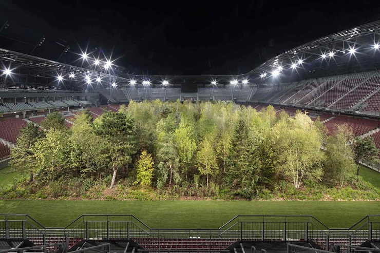
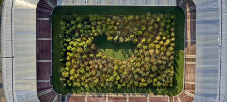
Wörthersee Stadion is a multi-purpose stadium in Klagenfurt, Austria. It is the home ground of Austria Klagenfurt. The stadium is situated within the Sportpark Klagenfurt campus of several other sports venues. Its name refers to the nearby Wörthersee lake.
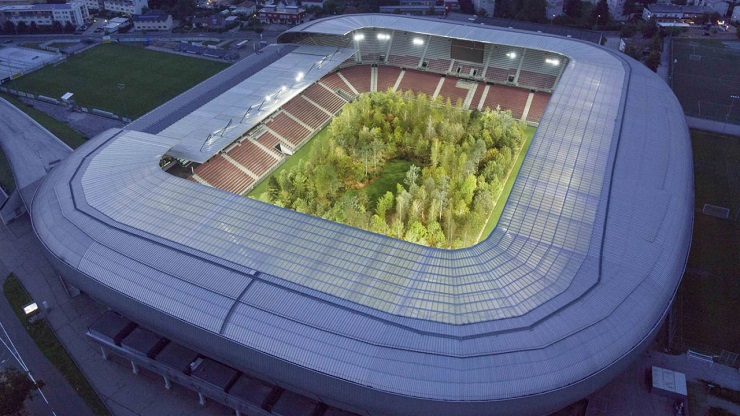
The stadium was the site of Klaus Littmann’s For Forest–The Unending Attraction of Nature, Austria’s largest public art installation which took place from 8 September to 27 October 2019. The exhibition, inspired by Max Peintner’s pencil drawing The Unending Attraction of Nature from the 1970s and landscaped by architect Enzo Enea, was a 300-tree Central European forest occupying an entire football pitch. The project was a warning that nature in general and specifically forests might be confined to specially designated spaces if humanity continued to take it for granted. Partly funded by sponsors who each contributed €5,000, it was open to the public free of charge daily from 10am to 10pm CET. Austria Klagenfurt home matches were temporarily played at the adjacent Karawankenblick Stadion. The trees were replanted in locations near the campus following the exhibition’s conclusion.
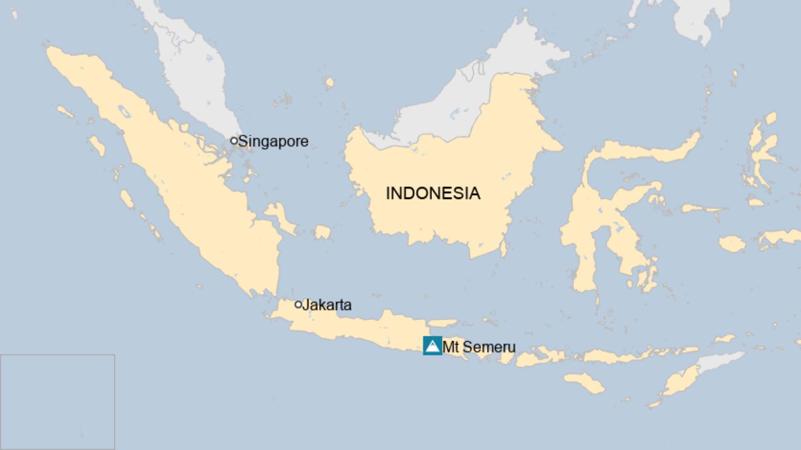
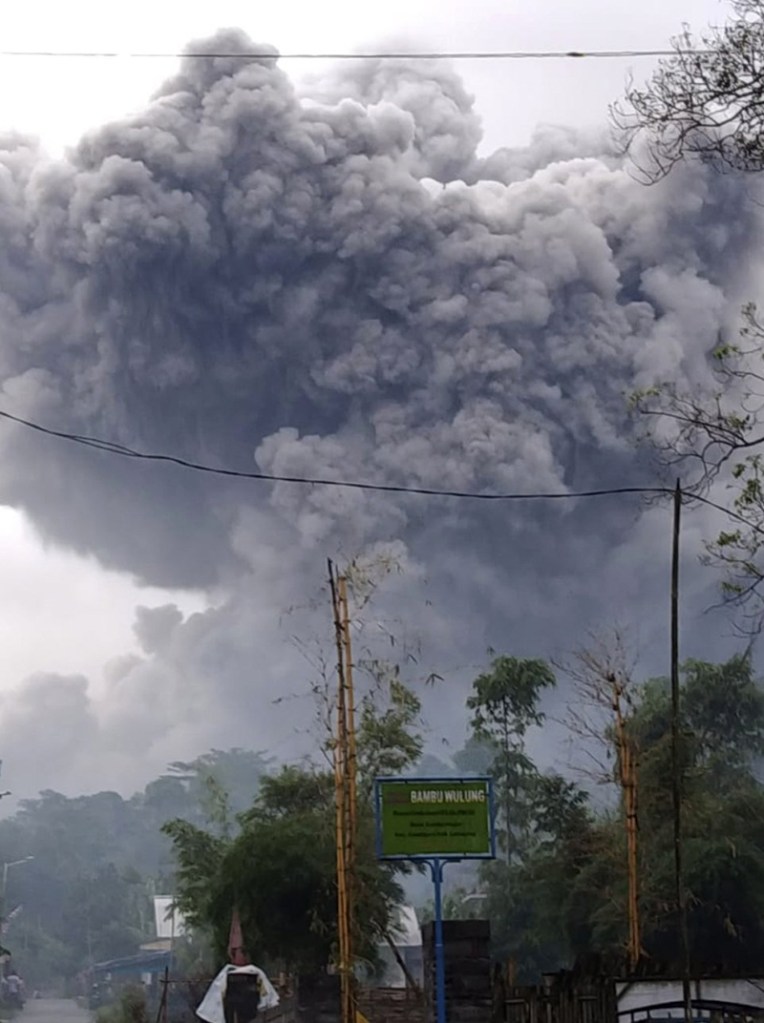
Residents on the Indonesian island of Java have been fleeing a vast plume of ash as an active volcano erupted for the second time in months.
Witnesses said a thick rain of volcanic ash from Mt Semeru was blotting out the Sun in two local districts.
No casualties have yet been reported and evacuations are under way, officials said.
Meanwhile a monitoring body issued a warning to airlines of an ash cloud rising up to 15,000m (50,000 ft).
The eruption took place at about 14:30 local time (07:30 GMT). Local authorities have set up a restricted zone of 5km (3 miles) from the crater after the eruption.
Thoriqul Haq, a local official, told Reuters that a road and bridge from the area to the nearby city of Malang had been severed.
“This has been a very pressing, rapid condition since it erupted,” he said.
The Volcanic Ash Advisory Center (VAAC) in Darwin, Australia said the ash appeared to have detached from the summit and was drifting south-west over the Indian Ocean.
The VAAC provides advice to the aviation industry about the location and movement of potentially hazardous volcanic ash.
Campbell Biggs, a meteorologist at the VAAC, told the BBC that the 15,000m plume was higher than the cruising altitude for most aircraft and would cause most flights in the vicinity to divert their flight paths to avoid it.
Ash that solidifies on cooler parts of plane engines can disrupt airflow, which can lead to engines stalling or failing completely.
It also affects visibility for the pilots and can affect air quality in the cabin – making oxygen masks a necessity.
Mt Semeru was quite an active volcano that regularly spewed ash up to about 4,300m, so Saturday’s eruption was a “pretty significant increase in intensity”, Mr Biggs said.
The ash cloud should slowly dissipate, he said.
Mt Semeru rises 3,676m above sea level and previously erupted last December, forcing thousands of residents to seek shelter.
It is among Indonesia’s nearly 130 active volcanoes.
Indonesia is on the Pacific “Ring of Fire”, where continental plates meet causing frequent volcanic and seismic activity.
Footage on social media showed residents running away as a giant ash cloud rose behind them.
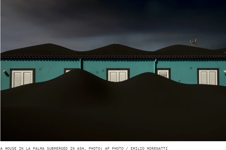
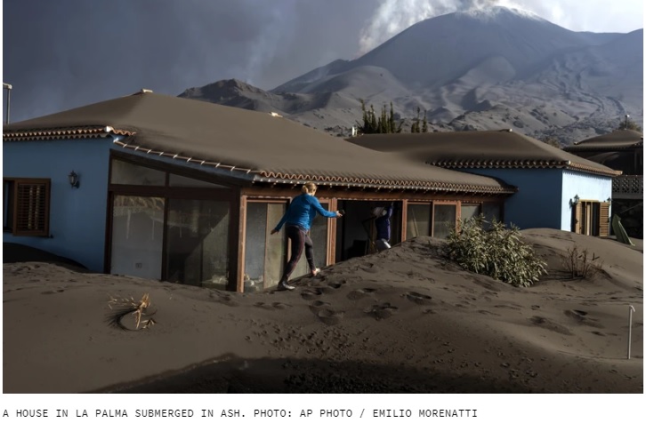
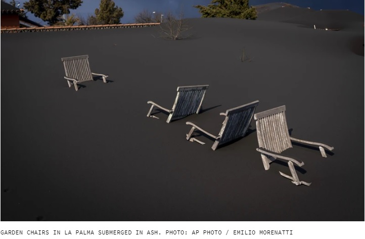
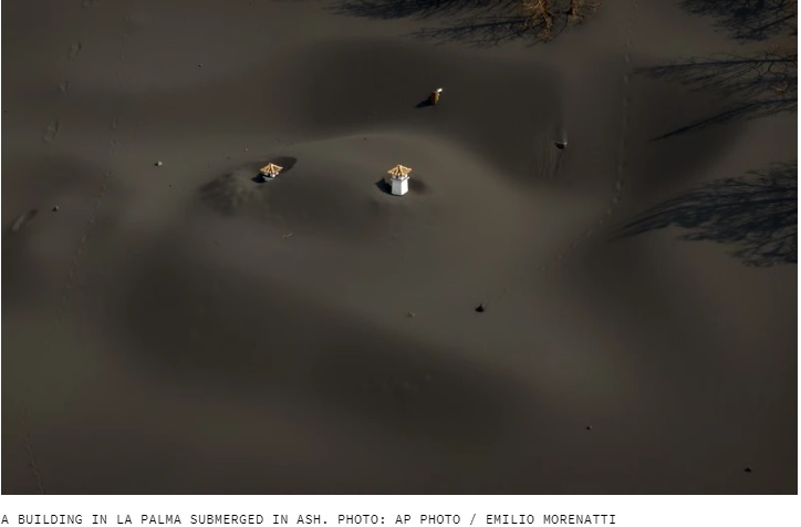
Parts of La Palma in Spain’s Canary Islands have been blanketed in thick layers of ash following the eruption of the Cumbre Vieja volcano.
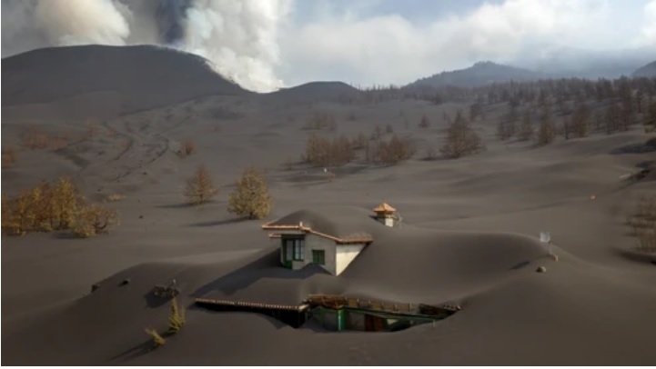
A HOUSE IN LA PALMA SUBMERGED IN ASH. PHOTO: AP PHOTO / EMILIO MORENATTI
Smoke is still flowing from the Cumbre Vieja volcano on the Spanish island of La Palma in the Canary Islands as it enters its eighth week of activity.
Scientists estimate that the Cumbre Vieja volcano has ejected more than 10,000 million cubic meters of ash since it first began erupting in September.
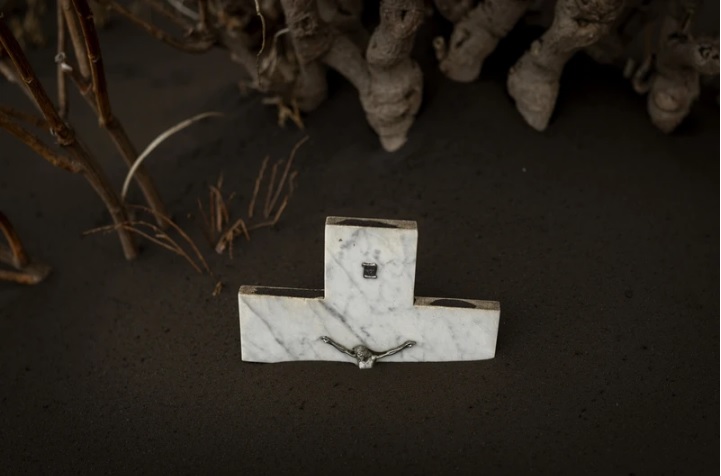
Otherworldly photos from the island show a surreal scene of homes, a cemetery and other buildings blanketed in pristine-looking ash, with entire structures submerged in untouched banks of dark grey ash.
The ash is shot thousands of meters into the sky, but the heaviest particles make their way down to the surface, slowly covering buildings.
There is no scientific evidence that the volcano will end anytime soon, according to Carmen Lopez, spokesperson for the Canary Islands Volcanic Emergency Plan (Pevolca). The emission of sulphur dioxide, an indicator of the volcano’s strength, fell on Saturday, but this is a normal fluctuation that doesn’t indicate an all clear, Lopez said.
According to state television channel RTVE, on Sunday winds blew a large black cloud of smoke to the south west of the island, allowing the airport to operate as normal – last week, flights had been cancelled. Nevertheless, authorities advised residents of several towns on the island with health problems to stay in their homes.
Emergency services connected to the Canary Islands government have said that the local air quality is “extremely unfavorable” because of the high level of small particles.
More than 7,000 people have been evacuated from their homes due to the threat from the rivers of lava.
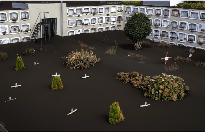
Cemetery covered in ash.
From Vice.com.
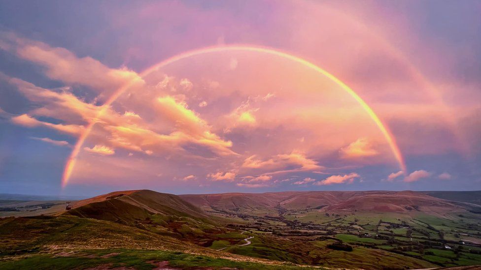
A photographer has captured a “mind-blowing” view of a full double rainbow from a Peak District summit.
Danny Shepherd took the photos from Mam Tor in Derbyshire at about 07:50 BST on Sunday.
He described the view over the village of Edale as a “one in a million colour party”, which lasted for about 20 minutes.

Mr Shepherd, who has been taking pictures in the national park for 20 years, said the view from the hilltop was always amazing, but said this was the first time he had seen anything like this.
“I’ve not seen a rainbow cover Mam Tor this way before,” he said. “[It was] pretty mind-blowing actually, to see both ends and it cover Edale.
“Mam Tor always delivers amazing views at sunrise but this was a first for a complete rainbow above us.
“I do a lot of Peaks photography so when this happened, I was like a kid in a sweet shop.”
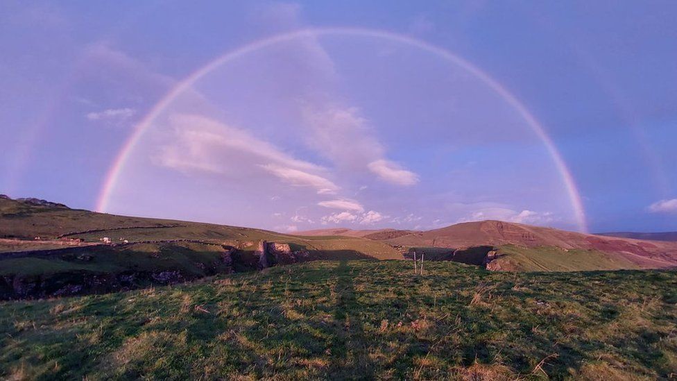
Paul Mullins saw the same full rainbow from Winnats Pass and said it was an “incredible surprise”.
He said: “As soon as I saw it, I had to capture the picture.
“I’m a keen hiker – I got up early to set off from Barnsley to make it in time for sunrise.
“I was hoping for a good sunrise, which I got, but the rainbow was an incredible surprise.”

BBC

Mono Lake is a large, shallow saline soda lake in Mono County, California, formed at least 760,000 years ago as a terminal lake in a basin that has no outlet to the ocean. The lack of an outlet causes high levels of salts to accumulate in the lake. These salts also make the lake water alkaline.
This desert lake has an unusually productive ecosystem based on brine shrimp that thrive in its waters, and provides critical nesting habitat for two million annual migratory birds that feed on the shrimp.

| Max. length | 15 km (9.3 mi) |
|---|---|
| Max. width | 21 km (13 mi) |
| Surface area | 45,133 acres (182.65 km2) |
| Average depth | 17 m (56 ft) |
| Max. depth | 48 m (157 ft) |
| Water volume | 2,970,000 acre·ft (3.66 km3) |
| Surface elevation | 6,383 ft (1,946 m) above sea level |
| Islands | Two major: Negit Island and Paoha Island; numerous minor outcroppings (including tufa rock formations). The lake’s water level is notably variable. |


The most unusual feature of Mono Lake are its dramatic tufa towers emerging from the surface. These rock towers form when underwater springs rich in calcium mix with the waters of the lake, which are rich in carbonates. The resulting reaction forms limestone. Over time the buildup of limestone formed towers, and when the water level of the lake dropped the towers became exposed.
![mono-lake-4[2]](https://markosun.files.wordpress.com/2013/02/mono-lake-42.jpg?w=1000)
![mono-lake-16[6]](https://markosun.files.wordpress.com/2013/02/mono-lake-166.jpg?w=1000)
![mono-lake-11[2]](https://markosun.files.wordpress.com/2013/02/mono-lake-112.jpg?w=1000)
![mono-lake-17[5]](https://markosun.files.wordpress.com/2013/02/mono-lake-175.jpg?w=1000)
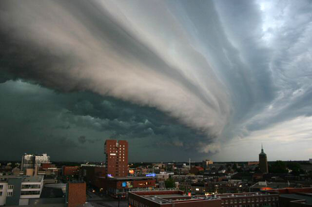
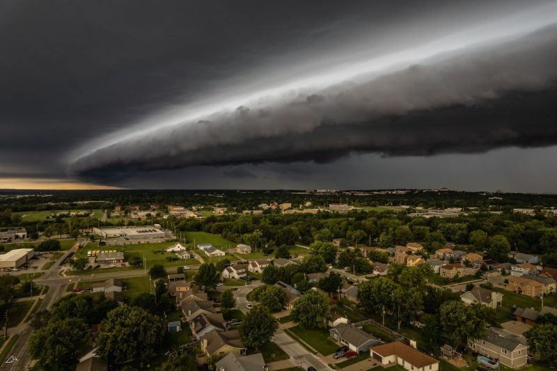
Mothership cloud is a nickname used by storm chasers for a type of Arcus clouds known as Shelf clouds.
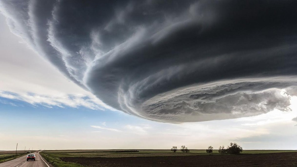
A shelf cloud is a low, horizontal, wedge-shaped arcus cloud. A shelf cloud is attached to the base of the parent cloud, which is usually a thunderstorm cumulonimbus, but could form on any type of convective clouds. Rising cloud motion can often be seen in the leading (outer) part of the shelf cloud, while the underside often appears turbulent and wind-torn. Cool, sinking air from a storm cloud’s downdraft spreads out across the land surface, with the leading edge called a gust front. This outflow cuts under warm air being drawn into the storm’s updraft. As the lower and cooler air lifts the warm moist air, its water condenses, creating a cloud which often rolls with the different winds above and below (wind shear).
People seeing a shelf cloud may believe they have seen a wall cloud. This is likely to be a mistake, since an approaching shelf cloud appears to form a wall made of cloud. Shelf clouds usually appear on the leading edge of a storm, while wall clouds are usually at the rear of the storm.
A sharp, strong gust front will cause the lowest part of the leading edge of a shelf cloud to be ragged and lined with rising fractus clouds. In a severe case there will be vortices along the edge, with twisting masses of scud that may reach to the ground or be accompanied by rising dust. A very low shelf cloud accompanied by these signs is the best indicator that a potentially violent wind squall is approaching. An extreme example of this phenomenon looks almost like a tornado and is known as a gustnado.

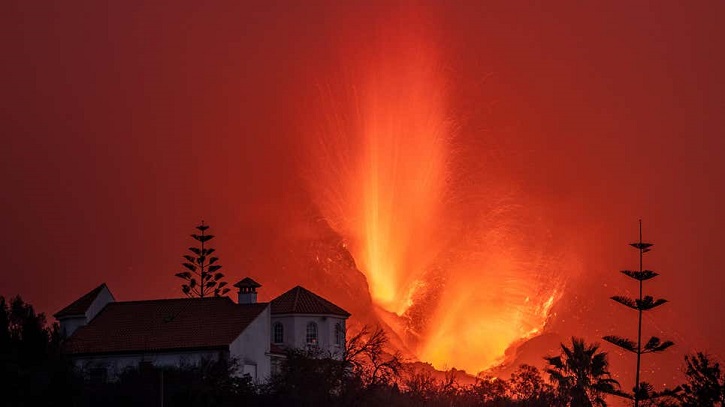
Cumbre Vieja’s eruption stepped up a notch over the weekend. The cone of the volcano erupting on one of the Canary Islands has partially collapsed, Spanish authorities said Saturday, sending rocks as big as three-story buildings tumbling down the hillside.
The Cumbre Vieja eruption on the Spanish island of La Palma started nearly three weeks ago. Lava has already engulfed nearly 1,200 buildings on its way to the Atlantic Ocean and forced thousands of people to evacuate. This explosion marks only the third time La Palma has erupted over the past 100 years: The first was in 1949 and then in 1971. And with the collapse of the cone, lava could continue its march of destruction.

New imagery captured by the European Space Agency shows the multiple trails of lava streaming from the volcano to the sea. Copernicus-2 satellite imagery taken on Sunday shows a new stream of lava caused by the collapse of the cone working its way to the Atlantic, as well as lava that has already reached the ocean from the previous stream.
A volcanic cone is the mound built by past eruptions. Sources at the Canary Islands’ Volcano Risk Prevention Plan told Spanish newspaper El Pais on Sunday that the cone’s collapse has caused a “notable rise” in the amount of lava flowing out of the volcano, as well as a few new lava streams they are monitoring. The collapse also caused the volcano to become more explosive.

Lava flows after the collapse of a part of the cone of the Cumbre Vieja Volcano on October 10, 2021 in La Palma, Spain.Photo: Marcos del Mazo (Getty Images)
“Last night was a hard night,” Pevolca technical director Miguel Ángel Morcuende told El Pais on Sunday. Authorities said that the cone’s collapse was not entirely unexpected, and they expect more of the cone to collapse as the volcano continues to erupt.

A car drives through an empty street in the neighborhood of La Laguna as lava flows from the Cumbre Vieja Volcano on October 9, 2021 in La Palma, Spain.Photo: Marcos del Mazo (Getty Images)
Since the volcano’s initial eruption, authorities have been keeping tabs on the lava flow and how it might impact La Palma’s 83,000 residents. While 6,000 people have been evacuated thus far and the lava has consumed homes, life has continued as usual for many on the island. The flow has largely affected a portion of the western side of the island, with ashfall also spattering areas immediately downwind.
Some of the new flow, authorities said, is tracking near where evacuations have already occurred, and they’ve allowed people whose homes might be in danger back into the exclusion zone to get their belongings. The AP reported that multiple trucks left the evacuated area on Saturday with loads of furniture and other household items.

The Cumbre Vieja volcano, pictured from Tijarafe, spews lava, ash, and smoke, on the Canary Island of La Palma, at night on October 10, 2021.Photo: Jorge Guerrero/AFP (Getty Images)
The lava on land isn’t the only danger. Cumbre Vieja’s molten rock river reached the sea late last month, 10 days after the eruption started. Hot lava hitting seawater can cause a reaction that emits a deadly mix of steam, toxic gas (including hydrochloric acid), and tiny shards of volcanic glass. This mix is known as “laze”—a portmanteau of “lava” and “haze”—which can cause breathing difficulties and irritate the skin of people who come in contact with it. Communities near where the lava is reaching the sea have been advised to stay inside and keep their windows shut.

The lava flow produced by the Cumbre Vieja volcano falls into the Atlantic Ocean, as seen from Tijarafe, in the Canary Island of La Palma on October 10, 2021.Photo: Jorge Guerrero/AFP (Getty Images)
The lava is also reshaping La Palma’s coastline as it meets the water and cools off. Experts estimate that the lava has already created 84 acres of new land. And there may still be more to come as the eruption shows no signs of stopping.
“We cannot say that we expect the eruption that began 21 days ago to end anytime soon,’’ said Julio Perez, the regional minister for security on the Canary Islands, told reporters over the weekend.

