From where countries import the most


High-speed rail map of Europe


Highest grossing movies filmed in each state.

Top selling cars in Europe by country


U.S. and Mexico

.
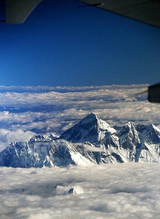
Mountain High
An astronaut on the International Space Station (ISS) snapped a picture of the United State’s Cascade and Rocky Mountains, as well as Canada’s Coast Mountains. An ISS solar array can be seen in the upper center part of the frame.

Cloudy Tail
A massive cloud of hydrogen streams from a Neptune-sized exoplanet due to the extreme radiation given off by the planet’s star. Researchers have never seen this occur around such a small planet dubbed – GJ 436b – before.

Auroras
Crew members on the International Space Station got a front seat view of this week’s auroras and captured this image.

Up, Up, and Away
A Soyuz rocket shoots into space from the Baikonur Cosmodrome in Kazakhstan on July 23. Three crewmembers bound for the International Space Station for a five month mission on board.

Sunlit
This is the first picture of Earth’s entire sunny side that NASA has released since the famous “Blue Marble” image in 1972. Images published in the interim have been stitched together from multiple pictures taken at different times.

Smoky
Satellites captured smoke from Canadian and Alaskan wildfires drifting over the Greenland Sea. Alaska has had its worst fire season ever, with millions of acres burned as of July 7. Over three million acres have burned in Canada as of July 15.

Solar Marble
Our sun glows in x-ray and ultraviolet light. High-energy x-rays are shown in blue, low-energy x-rays are green, and extreme ultraviolet light shines in yellow and green. Active regions flare up in bursts of white.

Drone photos
Snorkeling With Sharks
Snorkelers swim with sharks near Moorea Island in French Polynesia.

Lost Island
Tourists wait for a sunset in French Polynesia, a group of islands in the South Pacific.

Glorieto Rodolfo Sanchez Taboada
A cliff diver jumps into the ocean in Mazatlan, Mexico.

Above the Mist
The Cathedral of Maringa pokes through heavy fog in Parana, Brazil.

Mont-Saint-Michel
Mont-Saint-Michel is an island commune off the coast of Normandy, France.

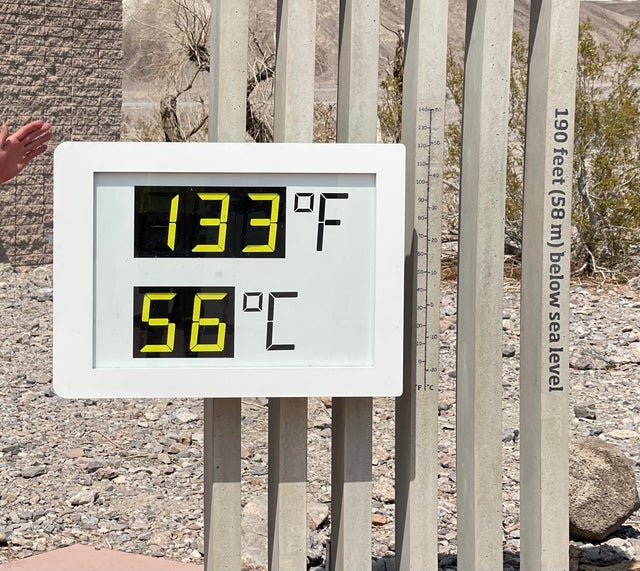
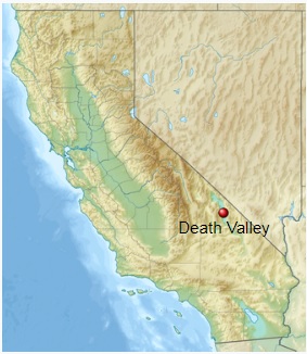
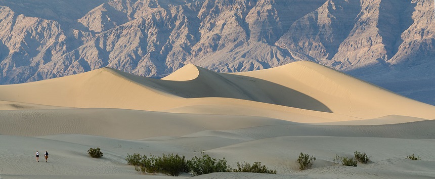
Death Valley is a desert valley in Eastern California, in the northern Mojave Desert, bordering the Great Basin Desert. During summer, it is one of the hottest places on Earth, along with deserts in the Middle East and the Sahara.
Death Valley’s Badwater Basin is the point of lowest elevation in North America, at 282 feet (86 m) below sea level. It is 84.6 miles (136.2 km) east-southeast of Mount Whitney, the highest point in the contiguous United States, with an elevation of 14,505 feet (4,421 m). On the afternoon of July 10, 1913, the United States Weather Bureau recorded a high temperature of 134 °F (56.7 °C) at Furnace Creek in Death Valley, which stands as the highest ambient air temperature ever recorded at the surface of the Earth. This reading, however, and several others taken in that period, a century ago, are in dispute by some modern experts.
Recent temp reading in Death Valley.

Aoga-shima island off the coast of Japan

Inishturkbeg Island off Ireland

Male, capital island city of the Maldives

Battleship Island, Japan. There was a coal mine under the island, the company built apartment buildings for the workers and their families. It was abandoned in the 1980’s.

Palau, South Pacific

Lejima Island, Japan

Sark Island, English Channel

Babel Island, off Tasmania

Thousand Island Lake, China

Small island off of Thunder Bay, Ontario

Whitsunday Island, Australia
Flateyri is a small fishing village located on a narrow strip of land at the edge of the sea in the picturesque Westfjords, in northwest Iceland. The village of only 300 has been a trading post since 1792 and saw its heyday in the 19th century when it became a major whaling center and base for shark-hunting. The fishing industry has always been vital for the villages in the Westfjords, and Flateyri had successfully married this tradition with tourism making the village a very popular destination for foreign sea anglers.
Like so many Icelandic villages, Flateyri is located on the seaside at the base of a steep, treeless mountain called Skollahvilft. The mountain is but steeper than usual and remains covered with snow for much of the year making it susceptible to avalanches. However, no major incident had occurred until one October morning in 1995.

It was 4 am on the 27th, and the residents of Flateyri were sleeping. Suddenly, they were awakened by a deafening roar as ice, rocks, and snow came crashing down the mountain. Seventeen homes, only one of which was thought to lie in the avalanche danger zone, were buried under snow and rocks. Local residents immediately attempted a rescue effort, but the snow had erased all landmarks and they had trouble locating where the houses were. The darkness made matters worse. Twenty people were killed that day. It took search parties two long and grueling days to locate all the bodies.
The disaster was the second deadly avalanche in the same region in ten months. In January, the people in the fishing village of Suðavík suffered a devastating avalanche where sixteen residents lost their lives. After that incident, people living in avalanche-prone areas became more prepared and cautious. As winter began the following October, high winds in the West Fjords prompted evacuations across the region. Hundreds of electric poles were snapped by the winds like twigs. Several avalanches occurred the day before the disaster at various places. In Langidalur, a herd of 18 horses were killed, while another slide destroyed a storage building in Sugandafjor.

Two deadly avalanches struck the Westfjords in 1995. One hit the town of Súðavík in January, killing 14, the other struck Flateyri in October, killing 20. Photo/GVA
In 1998, a special A-shaped earthen dam was built up the mountain to protect Flateyri from future avalanches. The structure consist of two deflecting dams that form a wedge or A-shaped structure in the mountain side. There is a small catching dam that extends between the two deflecting dams in the lowermost part. The walls are 600 meters long and 15-20 meters tall, while the catching dam is 10 meters high and 350 meters long.
Only a year after the dam was completed, in February of 1999, a large avalanche from the mountain came crashing down into the eastern side of the dam and went into the sea. The village was saved. The next winter, in March, another huge avalanche from the mountain slammed into the western wall and the village was protected again. Other smaller avalanches have occurred regularly, and each time the protection wall has deflected the snow safely away from the village.

A memorial to those who lost their lives.


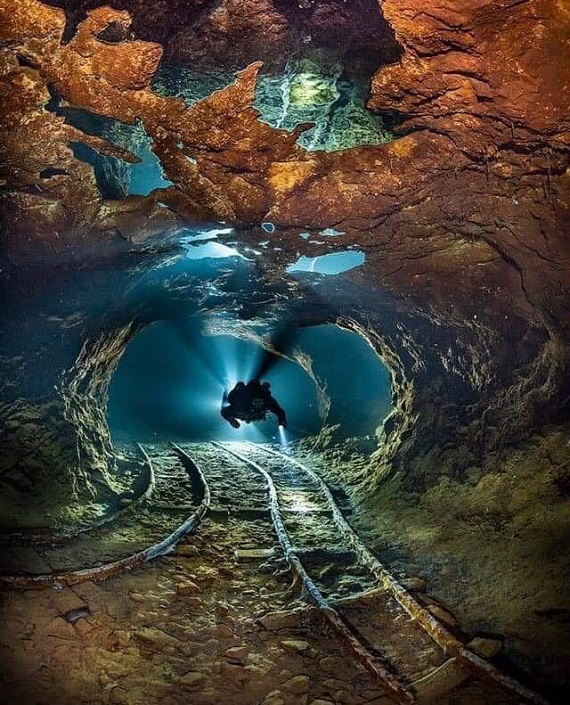
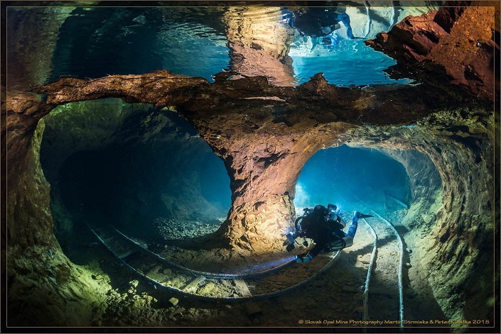
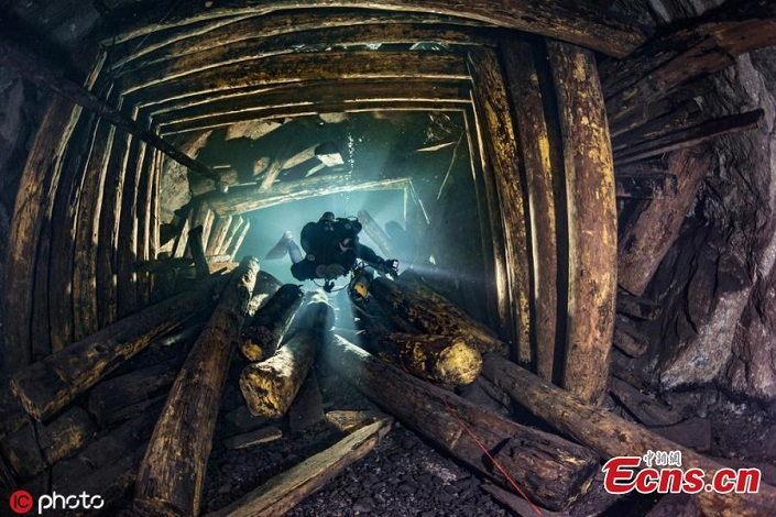
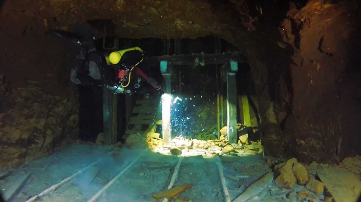
Divers exploring a flooded opal mine in Slovakia.

Mono Lake is a large, shallow saline soda lake in Mono County, California, formed at least 760,000 years ago as a terminal lake in a basin that has no outlet to the ocean. The lack of an outlet causes high levels of salts to accumulate in the lake. These salts also make the lake water alkaline.
This desert lake has an unusually productive ecosystem based on brine shrimp that thrive in its waters, and provides critical nesting habitat for two million annual migratory birds that feed on the shrimp.

| Max. length | 15 km (9.3 mi) |
|---|---|
| Max. width | 21 km (13 mi) |
| Surface area | 45,133 acres (182.65 km2) |
| Average depth | 17 m (56 ft) |
| Max. depth | 48 m (157 ft) |
| Water volume | 2,970,000 acre·ft (3.66 km3) |
| Surface elevation | 6,383 ft (1,946 m) above sea level |
| Islands | Two major: Negit Island and Paoha Island; numerous minor outcroppings (including tufa rock formations). The lake’s water level is notably variable. |


The most unusual feature of Mono Lake are its dramatic tufa towers emerging from the surface. These rock towers form when underwater springs rich in calcium mix with the waters of the lake, which are rich in carbonates. The resulting reaction forms limestone. Over time the buildup of limestone formed towers, and when the water level of the lake dropped the towers became exposed.
![mono-lake-4[2]](https://markosun.files.wordpress.com/2013/02/mono-lake-42.jpg?w=1000)
![mono-lake-16[6]](https://markosun.files.wordpress.com/2013/02/mono-lake-166.jpg?w=1000)
![mono-lake-11[2]](https://markosun.files.wordpress.com/2013/02/mono-lake-112.jpg?w=1000)
![mono-lake-17[5]](https://markosun.files.wordpress.com/2013/02/mono-lake-175.jpg?w=1000)