


Bison crossing a highway in northern Alberta.

Multiple simultaneous lightning strikes, Apache Junction, Arizona.

Interesting cloud formation over the South Dakota Badlands.

Young Orangutan uses a leaf for shelter during a rain storm. Bali, Indonesia.

Cheetah’s scanning for prey on a mound in Kenya. Shift change, when the second one arrived, the first one left the perch.

Wild fox at Chernobyl. Looks like it may be suffering from radiation poisoning.

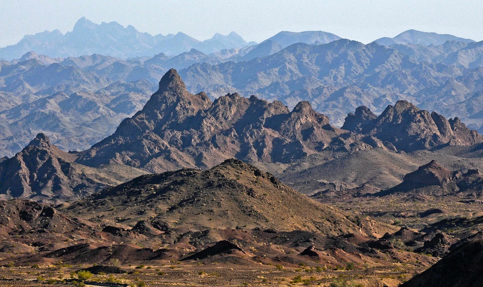
Coloured mountains in China. Various minerals in the soil create the striking colours.

Massive tornado in Colorado. It narrowly missed the farm yard.

Godafoss Falls, Iceland.

Sunset in Greece.

Beautiful ice cave in Iceland.

Iranian girls on the Iran-Iraq border. A destroyed tank left over from the Iran-Iraq War of the 1980’s. The girl on top of the tank opened her arms in the direction of Iraq in a gesture of defiance.

Mother Cheetah protecting her five cubs, a sixth had been killed by a lion.

Combines in formation, Minnesota.

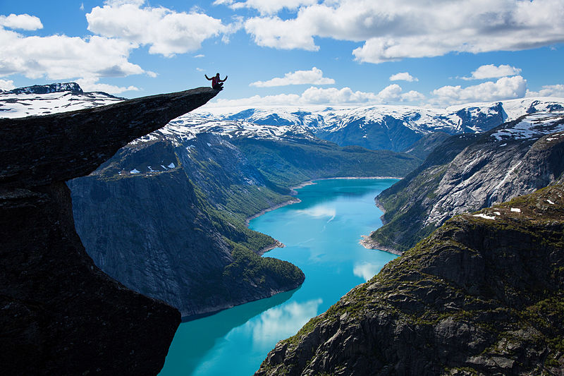
Beautiful fjord in Norway.

Great scenery on the Polish-Slovakian border.

Salt terraces in Peru.

Terraces in Vietnam.

Striking scenery, Albania.

Whitmore Hot Springs, California.

Wildebeests crossing a river on the Serengeti.

Residential zoning in Tibet. Except for a few holy Monk buildings, nothing gets built to the right of the line.
Chocolate topography exists on the planet. It is the color of these high areas that lead to the names. There is one in the Philippines and one in California.
The Chocolate Hills

The Chocolate Hills (Filipino: Tsokolateng Burol) are a geological formation in the Bohol province of the Philippines. There are at least 1,260 hills but there may be as many as 1,776 hills spread over an area of more than 50 square kilometres (20 sq mi). They are covered in green grass that turns brown (like chocolate) during the dry season, hence the name.

The Chocolate Hills form a rolling terrain of haycock hills – mounds of a generally conical and almost symmetrical shape. Estimated to be from 1,268 to about 1,776 individual mounds, these cone-shaped or dome-shaped hills are actually made of grass-covered limestone. The domes vary in sizes from 30 to 50 metres (98 to 164 ft) high with the largest being 120 metres (390 ft) in height.

The Chocolate Hills are conical karst hills similar to those seen in the limestone regions of Slovenia, Croatia, northern Puerto Rico, and Pinar del Río Province, Cuba. These hills consist of Late Pliocene to Early Pleistocene, thin to medium bedded, sandy to rubbly marine limestones. These limestones contain the abundant fossils of shallow marine foraminifera, coral, mollusks, and algae. These conical hills are geomorphological features called cockpit karst, which were created by a combination of the dissolution of limestone by rainfall, surface water, and groundwater, and their subaerial erosion by rivers and streams after they had been uplifted above sea level and fractured by tectonic processes.

The Chocolate Mountains of California are located in Imperial and Riverside counties in the Colorado Desert of Southern California. The mountains stretch more than 60 miles (100 km) in a northwest to southeast direction, and are located east of the Salton Sea and south and west of the Chuckwalla Mountains and the Colorado River. To the northwest lie the Orocopia Mountains.

The Chocolate Mountains form the northeast boundary of the Salton Trough extending as a narrow range some 80 miles (130 km) southeast from the Orocopia Mountains to the Colorado River valley. The mountains are located about 30 miles (48 km) west of the Chocolate Mountains of Arizona, but the two ranges are not connected. The range reaches an elevation of 2,475 feet (754 m) at Mount Barrow, and serves as a drainage divide for the Salton Watershed to the west.


The mountain range is occupied by the Chocolate Mountain Aerial Gunnery Range, an aerial and gunnery practice area used by the US Navy and Marines. A large part of the Chocolate Mountains lies within the gunnery range, and is closed to the public.

Size comparison between Belgium and Canada.
Belgium is the little purple inkblot.
While we’re at it, here are some more comparisons.

France (purple), Brazil (orange)

Australia (purple, orange), Russia (blue)

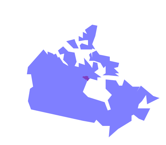
Manitoba (orange), Bangladesh (purple). FYI Manitoba has a population of 1.2 million, Bangladesh has a population of 168 million!

US (blue), UK (purple). We don’t always appreciate how much space we have in North America.

Sahara desert imposed over Canada. That is a giant sand dune, I’m getting thirsty just thinking about it.

Africa is utterly enormous. The purple is Germany.
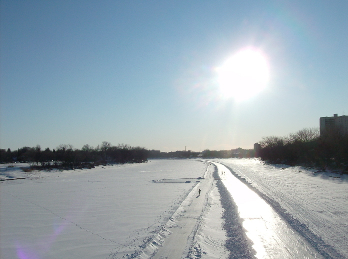
Frozen river in Winnipeg with skating trail
Flooded river in Winnipeg

Alaskan river

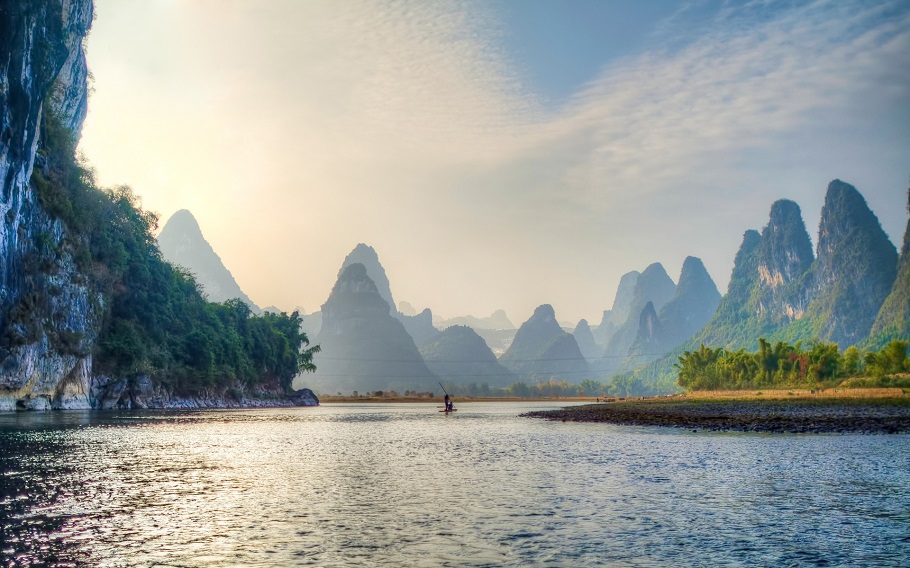
River in China
River flowing under a bridge in France

Grand Canyon

River in Greenland

River in Mali

River in the state of Nevada
River in the Swiss Alps

River in Utah
Horses crossing a river in Virginia

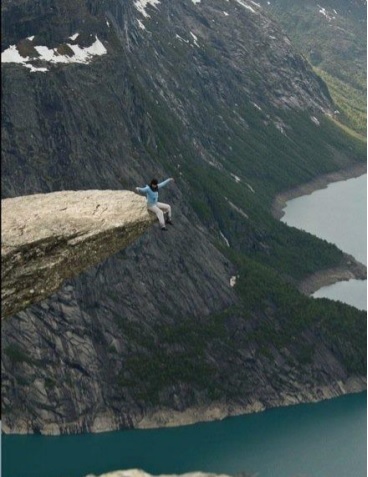
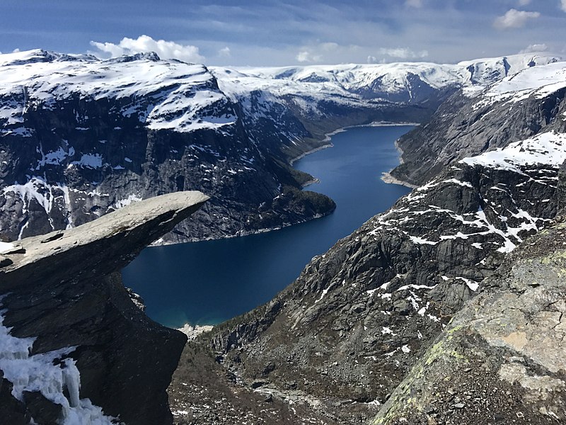
Trolltunga (“Troll tongue”) is a rock formation situated about 1,100 metres (3,600 ft) above sea level in Ullensvang Municipality in Vestland county, Norway. The cliff juts horizontally out from the mountain, about 700 metres (2,300 ft) above the north side of the lake Ringedalsvatnet.
Popularity of the hike to Trolltunga and rock formation itself has exploded in recent years. The increased popularity has turned Trolltunga into a national icon and a major tourist attraction for the region. Until 2010, fewer than 800 people hiked to Trolltunga each year. In 2016 more than 80,000 people hiked[3] the 27-kilometre (17 mi) round-trip from the village of Skjeggedal, making it one of Norway’s most popular hikes.
This is a very challenging hike, at least 10 hours on rough terrain. There are no shelters on the hike route and no places to buy supplies. However, there is a plan to build a lodge roughly halfway where hikers can rest.
Access
Trolltunga is located 17 kilometres (11 mi) from the town of Odda. The city of Bergen, is about 190 kilometres (120 mi) from the site via main roads.
The trailhead is located by a small parking area with toilet facilities at Skjeggedal, about 7 kilometres (4.3 mi) from Norwegian National Road 13 in Tyssedalen, near the dam at the end of Ringedalsvatnet. Parking costs 500 kr per day for the lower car park (approx. 62 USD or 52 EUR).
The hike from the parking area to Trolltunga and back again is a 27-kilometre (17 mi) round-trip distance with a 1,100-metre (3,600 ft) gain in elevation, and it takes approximately 10–12 hours, including breaks.
Near the parking area at Skjeggedal there is a funicular called Mågelibanen (it is not in operation). The trail to Trolltunga begins here, on the left side of the funicular. It is marked with red Ts painted in the terrain, and signs along the route that marks the distance left to Trolltunga and to the starting point at Skjeggedal.
For the first 1.5 kilometres (0.93 mi), up to the Måglitopp, the trail rises about 450 metres (1,480 ft). From here the track surfaces slightly out before it gets steep again, rising another 330 metres (1,080 ft) up from Gryteskaret to Trombåskåret. This section is the steepest part on this hike. But in recent years this section have been improved by Nepalese sherpas, making it easier to traverse.
After this 4-kilometre (2.5 mi) steep climb from the parking area, the next section slopes down towards Store Floren. The trail continues over Hesteflåene and the dried out river Endåno, before it gets steeper up to Endanuten and crosses the dried river to Tyssestrengene. From here the trail goes on past glacial potholes, then continues past Tysshøl, and finally approaches Trolltunga, about 13.5 kilometres (8.4 mi) from the starting point at Skjeggedal.

Safety
Thousands of tourists visit Trolltunga during the four summer months, a number which has greatly increased from 500 per year to 80,000 between 2009 and 2016. No safety railing has been constructed on the edge of the cliff so as not to harm the natural beauty of the cliff, although a few small metal hooks have been installed as footholds to climb down to the rock.
On 5 September 2015, a 24-year-old Australian woman fell to her death off Trolltunga. It is believed to be the first recorded death from a fall there.
There are widely publicised photos of people hanging off the cliff or doing a hand stand on it. Most often they are manipulated. The elite climber Magnus Midtbø suspended himself from Trolltunga wearing a safety harness, but a version where the rope was erased has been spread in media.
The approach to and retreat from Trolltunga is a demanding hike, and 10–12 hours are needed for the round trip. In later years there have been up to 40 rescue actions annually. Surprisingly not because of the dangerous cliff, but due to the demanding hike back to Tyssedal. People get lost in fog or get injured during the hike or don’t have the endurance for such a demanding hike.
It is planned to build a lodge halfway between Trolltunga and Tyssedal, which will provide accommodation for hikers en route from Trolltunga.
Personally I wouldn’t go anywhere near that ledge.
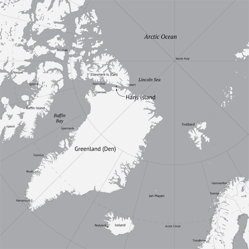
The Whisky War (also known as Liquor wars) is a pseudo-confrontation and border conflict between Denmark and Canada over Hans Island. Since the 1930s, Hans Island has been in the middle of a disagreement between the two nations.

Background
Hans Island is in the middle of the Kennedy Channel between Greenland and Ellesmere Island. A theoretical line in the middle of the strait goes through the island. Canada and Denmark could not come to terms on Hans Island in 1973 when a border treaty was signed, leaving a gap in its border description.
Conflict
In 1984, Canada provoked Denmark by planting its flag on the island and leaving a bottle of Canadian whisky. The Danish Minister of Greenland Affairs came to the island himself the same year with the Danish flag and a bottle of Snaps and a letter stating “Velkommen til den danske ø” (English: ‘Welcome to the Danish Island’).
Resolution efforts
Both countries agreed on a process in 2005 to resolve the issue.
Timeline
1980–1983 – Canadian firm Dome Petroleum did research on and around the island.
1984 – Tom Høyem, Danish Minister for Greenland, chartered a helicopter to the island, placing a flag and a bottle there.
1988 – The Danish Arctic Ocean patrol cutter HDMS Tulugaq arrived at the island, built a cairn and placed a flagpole and Danish flag on the island.
1995 – The Danish liaison officer and geodesists flew in and placed another flagpole and flag.
Late August 1997 – The Danish Arctic/Ocean patrol cutter HDMS Agpa tried to reach the island, but was forced to turn around 241 km (150 mi) from the Island, owing to extreme ice.
2001 – Keith Dewing and Chris Harrison, geologists with the Geological Survey of Canada who were mapping northern Ellesmere Island, flew by helicopter to the island.
August 13, 2002 – The Danish inspection ship HDMS Vædderen arrived and erected a new cairn, flagpole and flag, finding the 1988 flag missing and the 1995 flag in pieces.
August 1, 2003 – The crew of the Danish frigate HDMS Triton landed on the island and replaced the Danish flag again.
July 13, 2005 – Canadian soldiers land on the Island, placing a traditional Inuit stone marker (Inukshuk) with a plaque and a Canadian flag.
July 20, 2005 – As a symbolic move, Canadian Defence Minister Bill Graham set foot on the island.
July 25, 2005 – A Danish government official announced Denmark would issue a letter of protest to Canada.
July 25, 2005 – Deputy premier of Greenland, Josef Motzfeldt, stated the island had been occupied by Canada, stating experts should determine which country the island belongs to.
July 28, 2005 – The Danish Ambassador to Canada published an article in the Ottawa Citizen newspaper regarding the Danish view on the Hans Island issue.
August 4, 2005 – The Danish Arctic/Ocean patrol cutter HDMS Tulugaq was sent from Naval Station Grønnedal to Hans Island to assert Danish sovereignty. The cutter was expected to arrive in three weeks’ time.
August 8, 2005 – Danish newspapers reported Canada wished to open negotiations regarding the future of Hans Island. The news was welcomed by Danish Prime Minister Anders Fogh Rasmussen who stated “It is time to stop the flag war. It has no place in a modern, international world. Countries like Denmark and Canada must be able to find a peaceful solution in a case such as this.”
August 16, 2005 – According to Danish Foreign Minister Per Stig Møller, Denmark and Canada agreed to reopen negotiations regarding the future of Hans Island. Denmark would immediately begin geological surveys in the area, and Per Stig Møller would meet his Canadian counterpart Pierre Pettigrew in New York City in the middle of September. Should they fail to reach an agreement, both governments have agreed to submit the dispute to the International Court of Justice in The Hague. The government of Greenland agreed to this course of action. Regarding the Danish patrol cutter HDMS Tulugaq then en route to Hans Island, the minister stated “I have instructed the ship to sail there, but they will not go ashore tearing down [the Canadian] flag and replacing it with a new one. It would be a somewhat childish [behaviour] between two NATO allies.”
August 20, 2005 – Canada’s Foreign Affairs Minister, Pierre Pettigrew, stated Canada’s claim to the island had a firm basis in international law and would likely not end up before a world court. “Our sovereignty over the island has a very strong foundation,” the minister said in a telephone interview with a Canadian Press journalist.
September 19, 2005 – According to Canada’s Foreign Affairs Minister, Pierre Pettigrew, Canada and Denmark have agreed on a process to resolve the dispute over the island. Pettigrew and his Danish counterpart, Per Stig Møller, met in New York on this day. Pettigrew said the two countries would work together “to put this issue behind us.” However Pettigrew reiterated Canada has sovereignty over the island.
August 16, 2006 – A Vancouver geologist receives a prospecting permit for Hans Island from the Canadian government.
March 17, 2007 – Scientists from the University of Toronto and the Technical University of Denmark announced plans to install an automated weather station on the island, some time in the summer of 2007.
July, 2007 – Canada updates satellite photos and recognizes its line constructed for the earlier maritime agreement would have run roughly through the middle of the island; negotiations continue with Denmark over establishing an international land boundary or island sovereignty.
May 4, 2008 – An international group of scientists from Australia, Canada, Denmark, and the UK installed an automated weather station on Hans Island.
April 11, 2012 – Proposal for Canada and Denmark to split Hans Island.
November 29, 2012 – Canada and Denmark settle an agreement on the exact border between them, though without defining the border near Hans Island.
May 23, 2018 – Canada and Denmark announce a Joint Task Force to settle the dispute over Hans Island.
February 2019 – Canadian geologist John Robins is granted a minerals exploration claim for Hans Island by the Canadian government as part of efforts to help the cause of Canada’s sovereignty claim.
September 12, 2019 – The Government of Greenland decided to approve a temporary closure of Hans Island for the application for mineral exploration permits. This approval was based on an agreement between the Government of Canada and the Kingdom of Denmark. The Canadian geologist John Robins therefore also had his minerals exploration claim for Hans Island suspended by the Canadian government. The Dane Andreas G. Jensen also had his application for mineral exploration permit rejected by the Kingdom of Denmark, because of this closure agreement.
| Belligerents | |
|---|---|
| Casualties and losses | |
| Snaps and Danish flags | Whisky and Canadian flags |
Andrej Ciesielski scaled the legendary monument back in 2017 in a daring daylight climb that amazingly only took him about 8 minutes to accomplish.
Despite being spotted by police during his ascent, Ciesielski continued to the top of the pyramid to savor the once-in-a-lifetime view and document his incredible feat.
Upon returning to ground level, the young man was arrested and could have faced up to three years in jail for the stunt.
He was eventually released after agreeing to let authorities delete the footage and photos from his climb.
Fortunately, Ciesielski had a way to recover the digital material and is now sharing the evidence of his awesome adventure with the world.
One slip and it’s going to be a head-over-heels crash that could cause permanent damage.


After a hard day of pyramid climbing, go to the KFC and indulge in local chicken cuisine.

Train Attendants


Tumpak Sewu, also known as Coban Sewu, is a tiered waterfall that is located between the Pronojiwo District, Lumajang Regency, and the Ampelgading District, Malang Regency, in East Java, Indonesia. The waterfall is overshadowed by Semeru, an active volcano and the highest mountain in Java. The Glidik River, which flows down Semeru, is the primary water source for the waterfall. Tumpak Sewu is loosely translated to mean “a thousand waterfalls” in the Javanese language. The name likely originated due to its appearance of many different waterfalls in one single, semi-circular area.
Tumpak Sewu is a highly-visited tourist destination, primarily on the weekends. Infrastructure built around and inside the main box canyon has allowed for easier access to the area, although the trip to enter or exit is still physically demanding and may take around an hour to complete.


