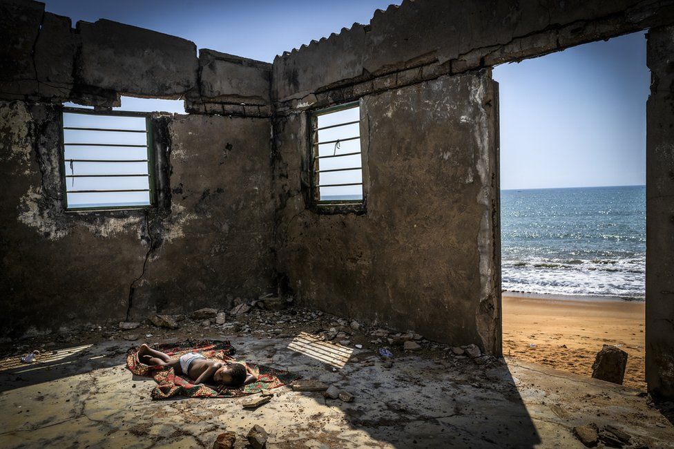
Spanish photographer Antonio Aragón Renuncio has won Environmental Photographer of the Year 2021 for his photo of a child sleeping inside a house destroyed by coastal erosion on Afiadenyigba beach in Ghana.
The image, entitled The Rising Tide Sons, highlights the rising sea levels in West African countries, which are forcing thousands of people to leave their homes.
Mr Renuncio receives £10,000 prize money.
The Environmental Photographer Of The Year competition, now in its 14th year, showcases some of the world’s most inspirational environmental photography.
The award celebrates humanity’s ability to survive and innovate and supports the calls to action in the United Nations Sustainable Development Goals.
The winners of this year’s competition were revealed at the UN Climate Change Conference (COP26) in Glasgow.
Here are other winning photos from the competition, with descriptions by the photographers.
Young Environmental Photographer of the Year: Inferno, by Amaan Ali, taken in Yamuna Ghat, New Delhi
“A boy fighting fires in a forest near his home in Yamuna Ghat, New Delhi, India.”
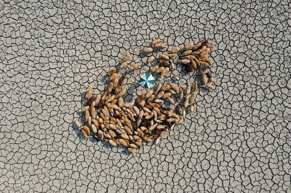
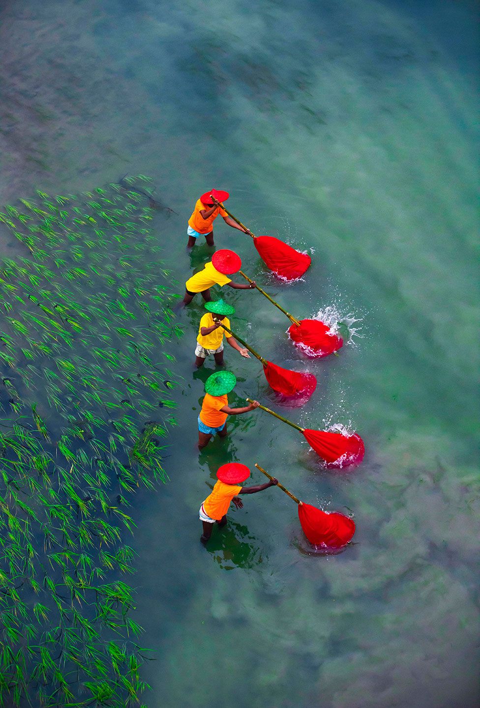
The Resilient Award: Survive for Alive, by Ashraful Islam, taken in Noakhali, Bangladesh
“Flocks of sheep search for grass amongst the cracked soil.
“Extreme droughts in Bangladesh have created hardships for all living beings.”
Sustainable Cities winner: Net-zero Transition – Photobioreactor, by Simone Tramonte, taken in Reykjanesbær, Iceland
“A photobioreactor at Algalif’s facilities in Reykjanesbaer, Iceland, produces sustainable astaxanthin using clean geothermal energy.
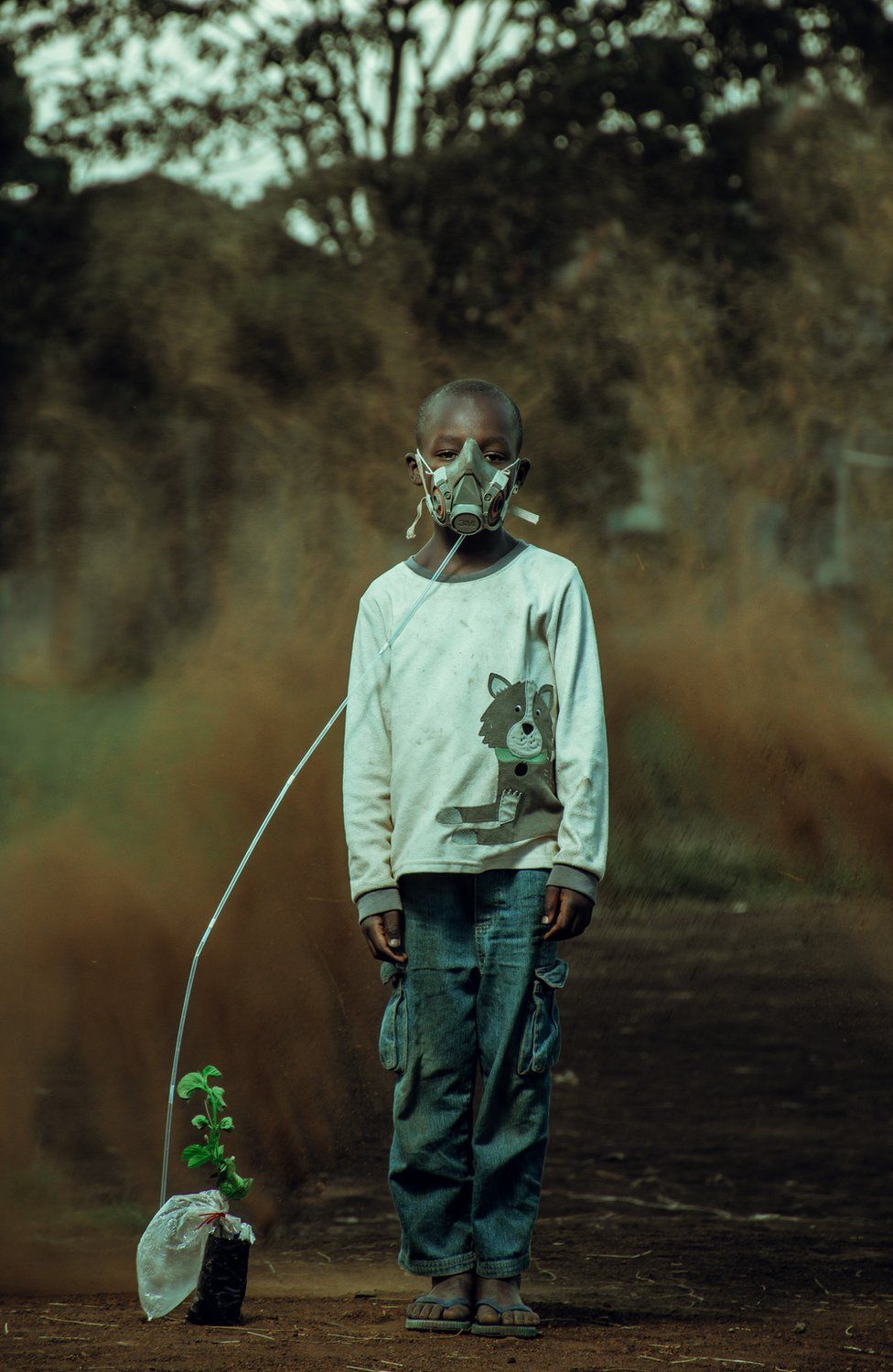
Climate Action winner: The Last Breath, by Kevin Ochieng Onyango, taken in Nairobi, Kenya
“A boy takes in air from the plant, with a sand storm brewing in the background, in an artistic impression of the changes to come.”
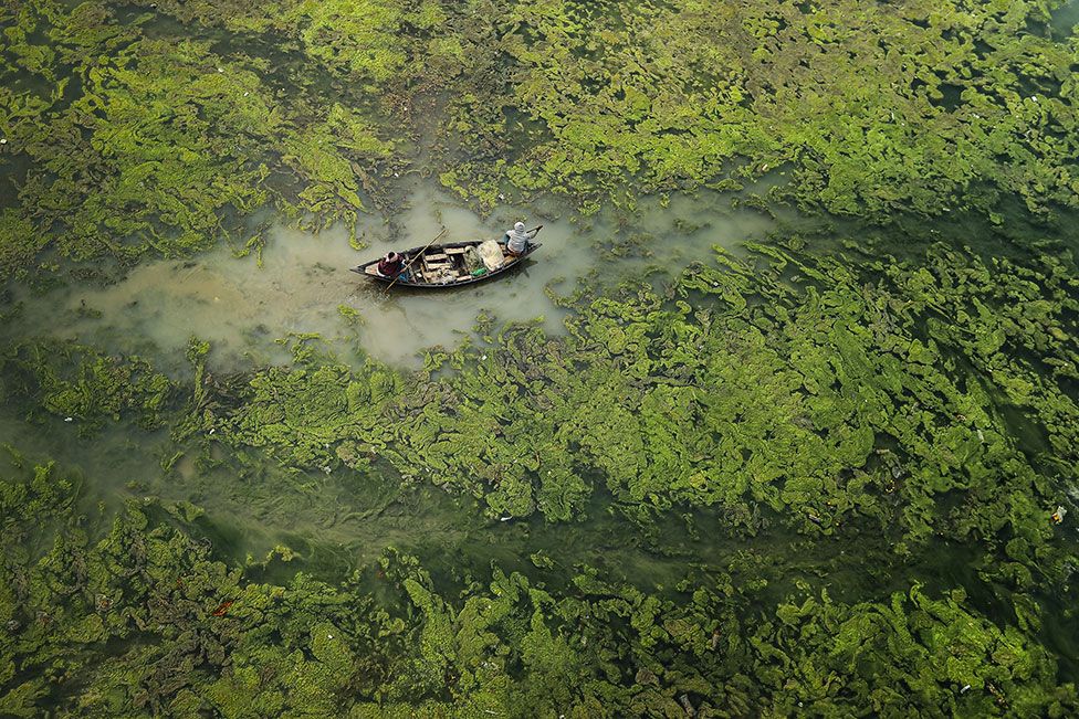
Water and Security winner: Green Barrier, by Sandipani Chattopadhyay, taken at Damodar river, West Bengal, India
“Irregular monsoon seasons and droughts cause algal bloom on the Damodar river, India.
“Algal blooms prevent light from penetrating the surface and prevent oxygen absorption by the organisms beneath, impacting human health and habitats in the area.”
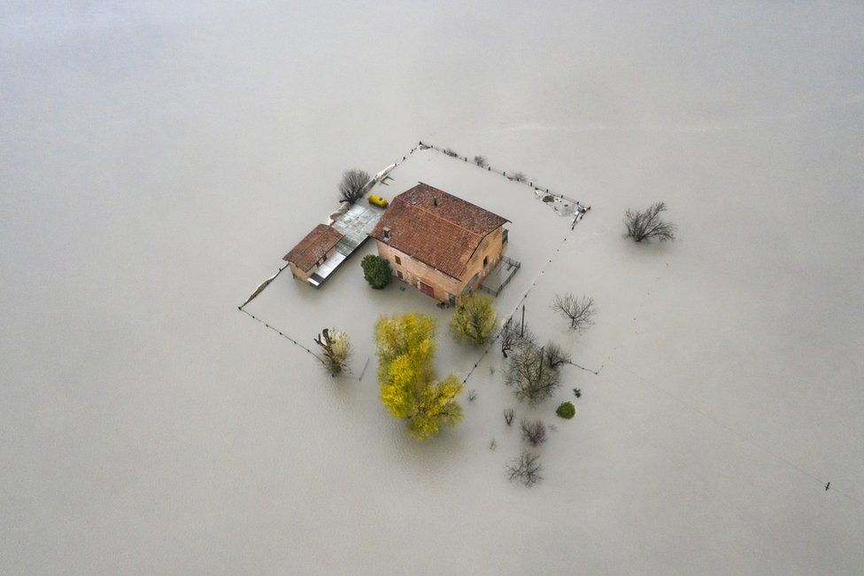
Environments of the Future winner: Flood, by Michele Lapini, taken at River Panaro, Nonantola, Modena, Italy
“A house is submerged by the flooding of the River Panaro in the Po Valley due to heavy rainfall and melting snow.”
Here are some of the shortlisted images in the competition.
Fishing in River, by Ashraful Islam, taken in Sirajgong, Bangladesh
“Algae accumulates and fills the whole river, then many boatmen come here to fish in the water.
“The river is filled with green moss.”
Drying Incense, by Azim Khan Ronnie, taken in Hanoi, Vietnam
“Vietnamese workers sit, surrounded by thousands of incense sticks in Quang Phu Cau, a village in Hanoi, Vietnam, where the sticks have been traditionally made for hundreds of years.
“Incense plays an important role in the spiritual lives of Vietnamese people.”
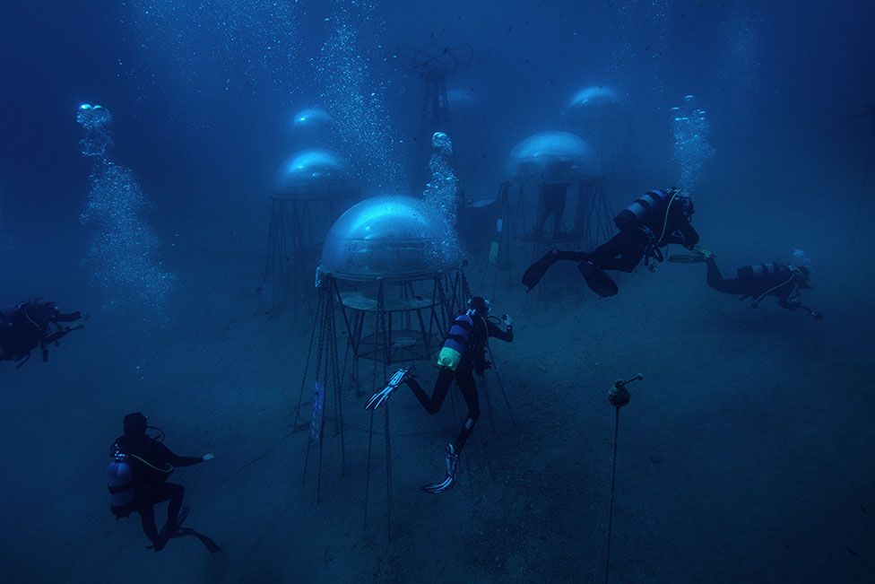
The Nemo’s Garden, by Giacomo d’Orlando, taken in Noli, Italy
“The Nemo’s Garden represents an alternative system of agriculture especially dedicated to areas where environmental conditions make plant growth extremely difficult.
“This self-sustainable project aims at making underwater farming a viable eco-friendly solution to counteract the increasing climate-change pressures on our future.”
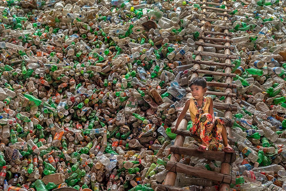
Environment Confined in Plastic, by Subrata Dey, taken in Chittagong, Bangladesh
“I captured this picture from a plastic-recycling factory in Chittagong, Bangladesh.
“Plastic recycling helps protect the environment from plastic pollution and greenhouse gas emissions.”
Clean Energy, by Pedro de Oliveira Simões Esteves, taken in Serra de São Macário, Portugal
“Wind-energy turbines, moments before the sun sets over the mountains on a cloudy day.”
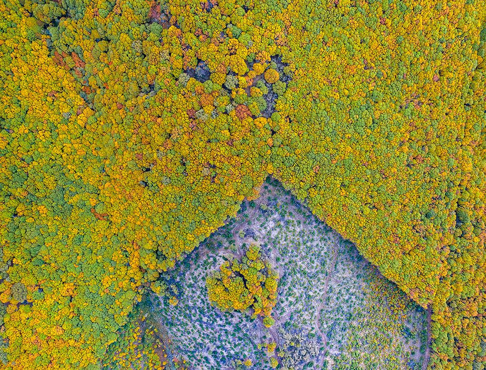
The Polygonal Forest, by Roberto Bueno, taken in Sierra de Béjar, Salamanca, Spain
“A good management of forests is fundamental to contain climate change.
“This is a chestnut forest managed by wood owners in a sustainable way.
“They cut trees in polygonal areas and in the middle of them they leave smaller areas with trees that help the natural reforestation of the wood.”
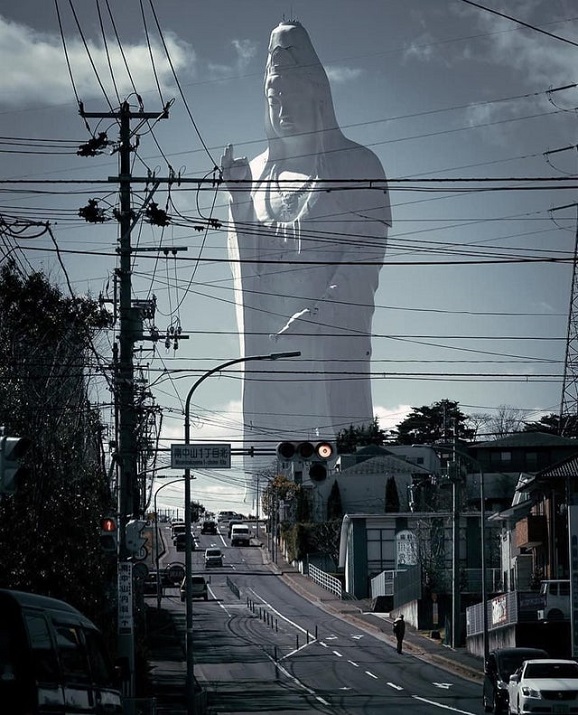
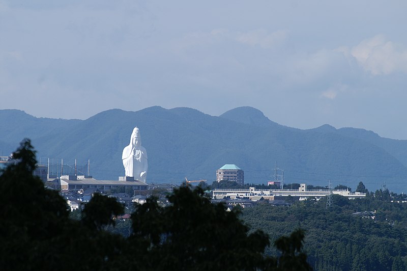
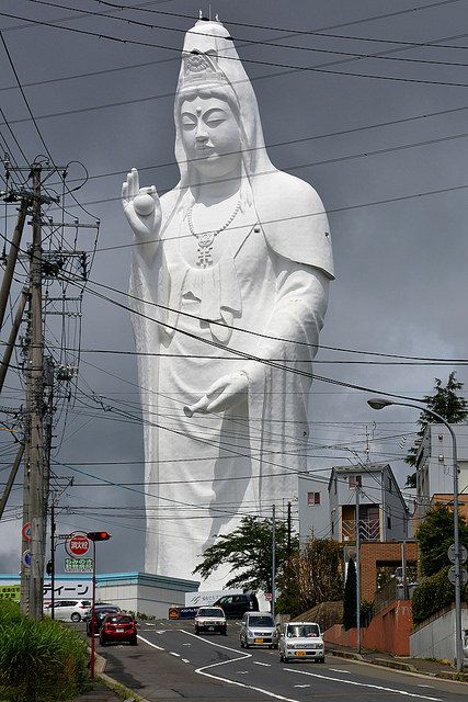
Sendai Daikannon, officially known as the Sendai Tendou Byakue Daikannon,is a large statue of Byakue Kannon bearing a gem in her hand located in Sendai, Japan.
It is among the tallest statues in the world, and is the tallest statue of a goddess in Japan. As of 2018, it is the fifth tallest statue in the world at 100 metres (330 ft). At the time of its completion in 1991, it was the tallest statue in the world, but has since been surpassed for that title.
The statue depicts a manifestation of the Bodhisattva Kannon known as Byakue Kannon, meaning “White-robed Kannon”, bearing the cintamani gem (如意宝珠, Nyoihōju) in her hand.
There is a small entry fee to enter the statue itself. Inside on the first floor are many large statues of Buddha and mythical kings. Visitors take an elevator to the 12th level then walk down the stairs and ramps to the ground. At each level there are eight Buddhas displayed in timber cabinets, 108 in all.
“It’s heartbreaking in a way how much has been lost,” photographer David Doubilet told BuzzFeed News. “In some ways the photos are all that’s left, which is also a little crazy to think about.”
The ocean may truly be the final frontier — despite a long maritime history, we have only just begun to explore the waters that cover 70% of the globe. What lies beneath the surface, as opposed to at the edge of the horizon, has been a constant source of fascination for David Doubilet, a longtime underwater photographer.
Over the course of 50 years with National Geographic, Doubilet has pioneered the split-frame image showing both above and below the water’s surface in a single frame. His work examines the connection between the two worlds, proving a remarkable insight into the impact that humans have on a realm we know little about. A collection of his favorites is now available in a new book, Two Worlds: Above and Below the Sea, and he took the time to talk with us about what it’s like to shoot film underwater and why these pictures matter so much now.
David Doubilet
Gentoo and chinstrap penguins on an ice floe near Danko Island, Antarctica
How did this get started?
What I love about this is that the surface of the sea is the most important border on our planet. It divides the air world, the known world where we all live, and the water world, which, up till the last 75 years or so, has been something of a mystery. Underwater photographers really have been trying to connect people with the ocean.
These half-and-half images are my favorite images to make. It began with a vision that I had when I was around 9 years old, swimming around the jetty of the Ocean Beach Club in New Jersey. I would swim with my head above the water and see the lifeguard blowing his whistle at me, screaming. I’d see people on the beach, I’d see clouds passing by. I’d see a whole different world. And I put my head just below and here’s a silent, welcoming world full of shafts and green light and fish hiding beneath the boulders of the jetty, waving seaweeds, groups of passing fish. It was the boundary of Two Worlds.
Fast forward to a five-decade-long career as an underwater photographer and storyteller for National Geographic magazine. It’s been an incredible partnership that has provided the perspective of time in the sea and a platform to show the world these pictures, and at the same time, promoting curiosity, exploration, discovery, and creativity. When I began working underwater, I thought the oceans were infinite… I was wrong; they are fragile and finite. Over time, the story coverages started with discovery, and now we are circling back to conserving those discoveries — something I did not expect in my lifetime.
A part of the storytelling is to find an image that distills a sense of place in one frame. For me, that image is the half-and-half image — the one that connects the surface to the hidden world below. It is a joy to look for and make these photographs. Not every assignment produces a half-and-half picture, but I scout for them endlessly. Some succeed and some do not. I like the artistic and technical challenge of making them.
Lion’s mane jellyfish drifting in the shallow bays of Bonne Bay Fjord located in Gros Morne National Park, Newfoundland, Canada
Can you talk about that a little?
You have to use a camera with a super wide-angle lens and large round dome in the front, which corrects for the magnification of water. This original concept and design can be attributed to National Geographic photographer Bates Littlehales.
The first challenge: to light for the underwater half using submerged strobes. The next hurdle is focus in both surface and subsurface worlds. Shooting at highest f-stop helps accomplish this. And then there are the dreaded water droplets. There are always unwanted droplets that will appear in the image right where you do not want them to. You can rinse the camera dome repeatedly, use Rain-X, your own spit, a potato — yes, a potato — or in my case, I use toothpaste wiped on the dome and rinsed off. But by far the biggest challenge of all is finding that place that tells a story about two worlds in one frame.
You learned to photograph underwater on film, and you still encourage photographers learning to dive to start with black and white. Can you talk a little bit about what it’s like working underwater?
First of all, before digital, you had 36 exposures, and that’s it. That’s all you got [on a roll of film]. No one in their right mind would go underwater right now with a card that has only 36 pictures.
Number two, underwater, you can’t change lenses. And number three, you can’t see what you’re shooting, which is the most important. As my friend Jay Maisel would say, you shoot as much as you can, because paranoia pays. And finally, there’s focus, you know, everything underwater is one-third larger. So that’s what these big domes correct, and that’s what some of the special wide-angle lenses correct for.
With technology now, you get moments that you couldn’t get before. When you’re underwater, a lot of things happen with color. First of all, red disappears in literally a foot of water. If you go diving, a red shirt is red in the first foot of water; by like 10 feet, it’s kind of a maroon, by 60 feet, that red is black. And this is in clear, beautiful Caribbean or mid-Pacific water. So to restore the spectrum, you can now take down a strobe — we call it a bottle of sunlight — and you illuminate the side of a reef system. A black sponge then turns out to be brilliant crimson.
You have to be careful shooting — you just don’t want to tramp on everything — but the closer you are to something, the more brilliant the pictures are.
As far as marine mammals go, they’re in charge, they’ll either accept you or reject you. You’re not gonna scare a whale away because you’re in the water. The whale is gonna move and leave or they’ll come right by you and ignore you. Or the whale will look in your eye. I’ve had a turtle basically follow me all over, over a reef system, so much so that he would put his flippers around my tank and look over my shoulder, and it’s me and the turtle.
David Doubilet
The rich lily forest tumble beneath a dense canopy of papyrus in the deepwater Nxamaseri Channel of the Okavango Delta, Botswana.
That’s amazing. Can you talk a little bit about why this vision of above and below is particularly important now?
We are in a time and a place on this planet where everything is changing. It’s not just climate change that is affecting the oceans… there is overharvest, habitat destruction, and coral disease. We are at a crossroads, a time where we have to stop talking and start doing. I really just have a single goal: Connect people to the sea.
I mentioned before that the best thing that National Geographic has given me is the perspective of time in the sea. It’s the most valuable thing that I can imagine. I decided to put that to work.
As an example, it occurred to me that after five decades in the sea as a journalist, I have an archive that is basically the ocean through the lens of time. We now know that corals are a thermometer for the oceans and that temperatures are rising, causing loss of corals around the planet… But what does that really look like? I decided to go into my archives to locate healthy reef pictures and return to that exact same spot on the reef after severe coral bleaching events. I returned to the Great Barrier Reef and Guam. The mission was to create powerful pairs of before and after coral bleaching images that show a healthy reef then and coral cemeteries now… pairings that wake people up. Tumon Bay, Guam, appears in the book. We photographed there in 2005 and came back and photographed in 2017 after three years of coral bleaching. Coral bleaching happens when heat causes stress that in turn causes the coral to expel beneficial algae that also gives coral nutrients and its color. The triple bleaching event in Guam was extreme and the coral did not survive. The effect is alarming.
A sargassum canopy of macroalgae in the Sargasso Sea near Bermuda. The sargassum weed canopy acts as a nursery for countless marine creatures that need cover and protection from predation.
Can you talk a little bit about how diving has changed over the last 50 years? Like there’s obviously been bleaching events, but then are there other elements that have changed either in terms of technology or in terms of what you’re seeing?
The reefs have changed wildly in the [past] 50 years or even 60 years. I first saw a coral when my father took me down to the Bahamas when I was 12 years old. The coral reef was made up of these great forests of elkhorn coral, which is brown, wonderful-looking coral [that’s] kind of almost the redwoods of a good coral world. And beneath that waft endless schools of fish, and throughout the Caribbean, that’s what it used to look like. Now 90% of the elkhorn has vanished throughout its range.
But there are a few places where it hangs on and even thrives: The Gardens of the Queen, an archipelago 50 miles off the southern coast of Cuba where it survives because of a wonderful combination of geopolitics and geography. Fidel Castro had a great interest in the sea because he was a diver and he had foresight to preserve some areas. Now this corner of the Caribbean off Southern Cuba is a time capsule in the sea.
Yes, we must tell the hard truths about the challenges, but there is hope and resilience. Some corals survive the coral bleaching to reproduce, creating more heat-tolerant corals. We see effective conservation measures with the creation of Marine Protected Areas, UNESCO World Heritage Sites, and National Parks. We see shark sanctuaries like the Bahamas and Palau, where sharks are celebrated and considered valuable to both the economy and the environment.
Can you talk a little bit about how geopolitics and the ocean interact?
We have seen the greatest conservation wins where the conservation involves the community. They are sometimes called community-based marine protected areas, and we see them functioning very well in some areas of the Coral Triangle: the Philippines, Papua New Guinea, and Indonesia.
In some areas, it comes down to aggressive protection from poaching through eyes on remote reefs 24/7/365. An example of this is the Philippines’ coral crown jewel: Tubbataha Reefs Natural Park. Remote atolls in the center of the Sulu Sea. Accessible to diving tourists for only a few months, rangers reside on the reef 365 days a year guarding against poaching.
It’s heartbreaking in a way how much has been lost. Um, and in some ways the photos are all that’s left, which is also a little crazy to think about.
Final thoughts?
When I began diving, every dive was a voyage of discovery. It still is. Every time I go on the water, it’s still something exciting. However, now we are documenting the time in a place, and it may disappear. So it’s different; we’re also hopefully celebrating places that are going to be successful. As a journalist, this is telling the most important story on a planet and is ongoing. The greatest show on Earth is Earth itself.
Yes, the oceans are in trouble and our individual choices collectively make a big difference. We all rely on the sea for oxygen and other resources… we are stakeholders, and we should protect what is at stake whether we live on the coast or inland. I see incredible hope in #NextGenOcean and collaboration.
This book documents the largest, most important border on the planet… the surface of the sea. It is an invitation to know, understand, and protect the other 71% of planet Earth…
As the oceans go, so do we.
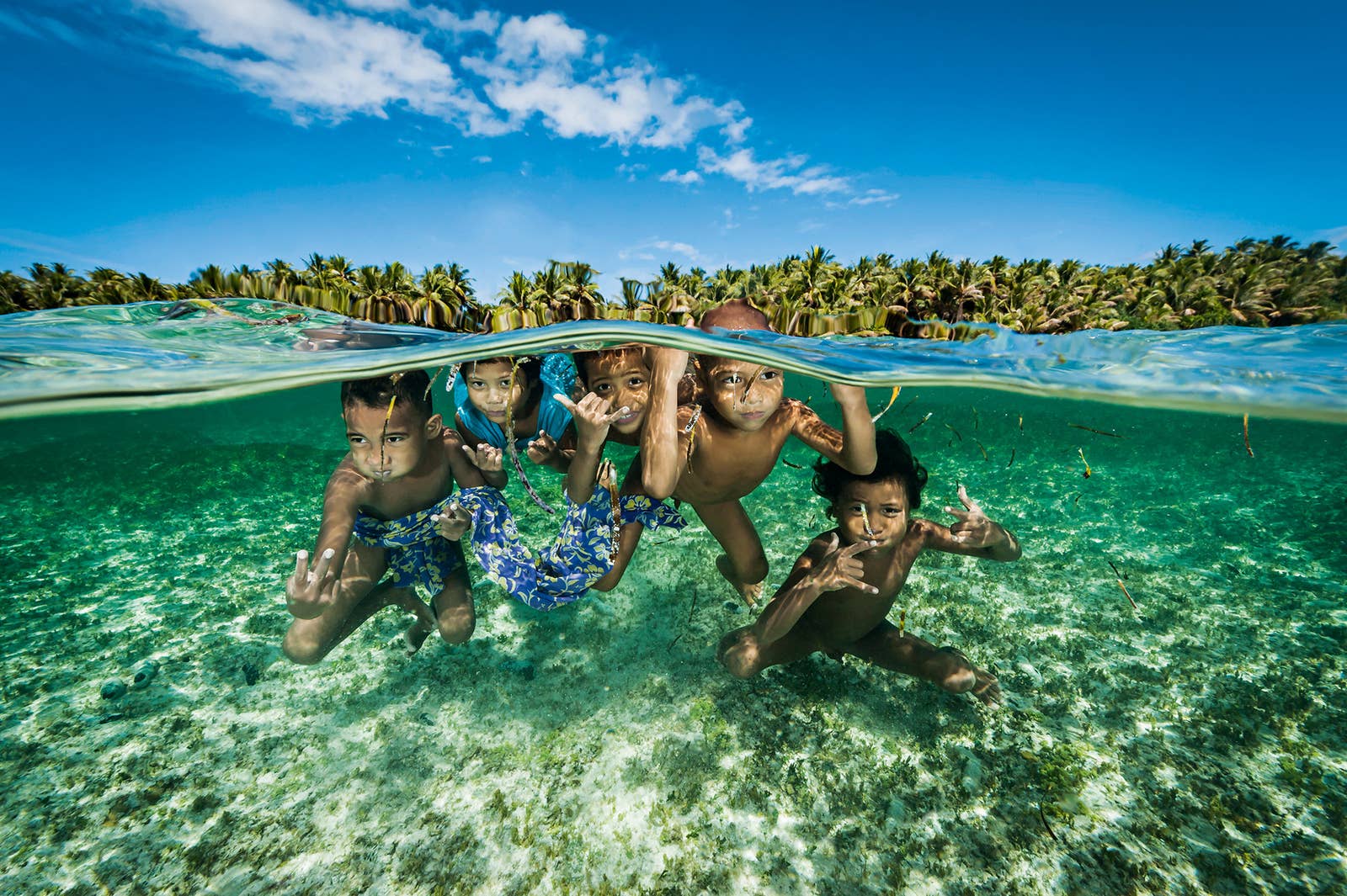
A fisher with his young son in an outrigger from a village on the Willaumez Peninsula on New Britain Island, Kimbe Bay, Papua New Guinea.
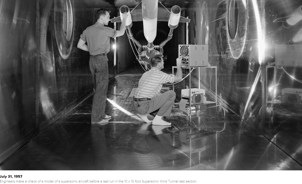
Before any NASA craft is cleared for liftoff, it must undergo exhaustive testing in one of the administration’s 42 major wind tunnels, which range from just a few inches wide to cavernous enough to contain a full-sized airplane.
With an aircraft model held on a stationary post, air is accelerated through the tunnel by fans, allowing engineers to study the effects of different designs on flight characteristics such as lift, drag and stability.
NASA’s earliest wind tunnel predates NASA itself, and was built in 1920 at the Langley Research Center, then under the auspices of the National Advisory Committee for Aeronautics (NACA).
As flight technology became more advanced and complex, so did the testing facilities. Specialized tunnels were developed to simulate subsonic, transsonic, supersonic and even hypersonic speeds — five times the speed of sound. Some tunnels can approximate the fiery heat of atmospheric re-entry, while others can test the effects of ice buildup at high altitudes. Some newer facilities can magnetically suspend aircraft models in midair, eliminating aerodynamic interference from support structures.
Today, NASA-operated wind tunnels are routinely used to test and tweak military and civilian aircraft.
Sept 11, 1959 A Mercury capsule model in the Spin Tunnel.
c. 1960
A 10-story bank of vanes which turn the air around one of the four corners of the 40 x 80-foot Wind Tunnel at Ames Research Center.
c. 1962
Technicians install a model of an Apollo command module in the 9 x 6-foot Thermal Structures Tunnel for tests of possible heat shield materials.
April 14, 1975
A space shuttle model undergoes a wind tunnel test simulating the ionized gasses that surround a shuttle as it reenters the atmosphere.
April 1, 1980
A Marshall Space Flight Center engineer holds a replica of the proposed Liquid Booster Module while observing the testing of a small Space Shuttle orbiter model at Wind Tunnel 14.
Nov. 17, 1986
NASA technician W.L. Jones inspects a transport model Pathfinder I between test runs at Langley’s National Transonic Facility.
April 10, 1990
The Pioneer Aerospace Parafoil undergoes testing in the world’s largest wind tunnel, the 80 x 120-Foot Tunnel at NASA’s Ames Research Center in Mountain View, California.
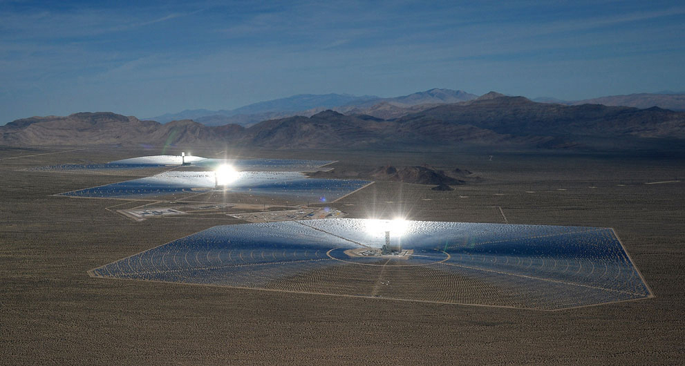
Some imaginative fellow was on an airplane flying over Nevada when he was sure he saw a giant UFO below the airplane. It was massive and giving off extremely bright lights. The guy must have thought Earth was under alien attack.
He took some photos below:
The “I want to believe” UFO community was abuzz when they saw the photos. Maybe some real evidence that the little green bastards do exist! But then a skeptic pointed out that the sighting was almost 99.999 percent a solar energy facility in the desert.
The Ivanpah Solar Electric Generating System is a concentrated solar thermal plant in the California Mojave Desert, 64 km (40 miles) southwest of Las Vegas, with a gross capacity of 392 megawatts (MW). It deploys 173,500 heliostats, each with two mirrors, focusing solar energy on boilers located on three centralized solar power towers. Unit 1 of the project was connected to the grid in September 2013 in an initial sync testing. The facility formally opened on February 13, 2014, and it is currently the world’s largest solar thermal power station.
There are ten huge Solar Generating facilities in the Mojave Desert. The airplane passenger should have done some research before he came to a UFO conclusion.
Dab smack in the middle of the eastern Canadian prairie is a tiny town called Somerset, Manitoba.
Somerset is sleepy little place where nothing much eventful ever happens. Farmers, mechanics and a few office workers going about their business. The main recreation in the place is gossiping about neighbors and talking about the latest casualty of old age. The towns population is overflowing with senior citizens. The only growth industry in town is the Old Folks retirement home.
Eventually the gossip began to speculate that there was a hoarder in town. Now this was interesting, the story really revved up the usually mundane restaurant chatter. As with all gossip, the facts are usually exaggerated and embellished. The chit chatters usually don’t care if the facts are unknown, they just like the story. But this time it was different.
The hoarder himself admitted that he was one. Constantijn Vanderrassle admitted to the local bartender that he had in fact been hoarding since the early 1990’s. It started after he retired from the railroad. He loved the things he bought from thrift stores, auctions and the picks he went on. And for the life of him he just couldn’t get rid of any of the stuff.
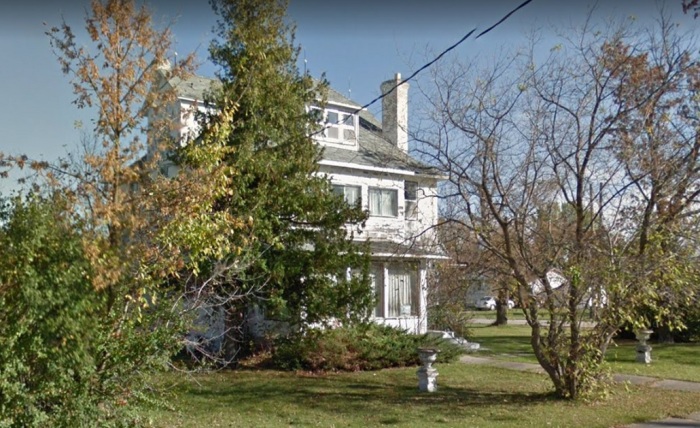
Constantijn’s house
A big structure with over a dozen rooms
After repeated requests Constantijn allowed the bartender Cletus LaFlesche to take a look. Cletus brought along his super dependable cannon XZ-500 digital camera and promptly snapped a picture of the living room.
Ignore the date in the bottom right corner, Cletus never did figure out how to set the clock on his camera. Since Constantijn was 92 years old Cletus wondered what in the hell he was doing with a little red wagon. Top left.
A few weeks after the visit something was bugging Constantijn that was causing him to drink more heavily than usual. He finally confided to Cletus that the damn house was haunted. He was seeing all kinds of weird entities. These phantoms, demons or whatever the hell they were, would throw the clustered hoarded things around in the middle of the night. Constantijn just couldn’t get any sleep.
One night, after the two buddies had drank many sambuca shooters and draft beers, they would go head first into the evil cauldron and Cletus would snap some pictures. The things in the pictures made the hair on Cletus’s neck stand on end. It was something out of a horror movie nightmare. Entities from hell!!
Bedroom
Bloody demon clowns!
WTF!!
Jesus Fricken Murphy!! The rancid breath that thing must exude.
Imagine waking up in the middle of the night to go for a leak and stumbling into this monstrosity. A guy could shit his pants!
From which hell pit did this quad eyed hideous mutation crawl up from? God help us all!!
And Constantijn did just that, he hired a servant of God to rid the house of the demon trolls.
Constantijn promised Cletus that if the Exorcist is successful, he will bring in the A&E hoarder psychiatrists and movers and get rid of all his stuff once and for all.
Source: from the depths of Markozen’s imagination.
When you think of surfing, Oahu, Bondi Beach, southern California and other tropical climes come to mind. But, believe it or not, they surf way up north in Duluth, Minnesota, in winter yet.
Why Winter Is Surfing Season in Minnesota
Catching a curl on a subzero Lake Superior isn’t easy, but some locals can’t get enough.
One of the biggest hits of the 1960s, the Trashmen’s “Surfin’ Bird,” originated in landlocked Minneapolis, where “hanging 10” seems laughably implausible. Up on Lake Superior, Minnesota’s surf scene is no joke. That is, unless catching a curl on subzero waters after brushing ice from your frozen eyelashes is funny to you. Papa-oom-mow-mow, cowboy.
“It kind of feels like a fairytale,” says “Big Wave” Dave Rostvold, who shapes boards by hand at his Duluth-based workshop Castle Glass Surfboards. “Surfing is a dream for a lot of people around the world. To be able to do it here in the Midwest, that’s a dream come true.”
After happening upon surfers working their magic on the frigid Superior waves, Joe Herron asked permission to photograph them. For both Herron and Rostvold, it took plenty of patience and study to gain any kind of confidence. Surfing is a deeply esoteric sport whose proponents are justifiably protective of their knowledge, especially in the North Shore’s frigid waters. Good waves are a finite resource, and mastering simple maneuvers, like “popping up” into a standing position, can be deeply humbling.
“It’s funny—I can both see that I’ve improved immensely since I started, but I’m also still really bad,” Herron says, chuckling. “It’s very tough, it’s physically demanding, it can be scary, but certain people just enjoy those kinds of activities.”
Bigger winds make bigger waves, which unfortunately means Superior is at its most surfable between November and February—when water temperatures barely tickle the high 30s. You need boots, gloves, and a high-quality, 6mm-thick hooded wetsuit. Herron says surfers warm up in their cars between “sets” of waves when temperatures become unbearable. He recalls photographing an experienced friend who somehow surfed for four straight hours in -17° windchill.
It’s easier to stay warm than you might think, though. All those waves mean you’re constantly in motion, to fight the current or stay in position. “What happens then is that your body heat gets elevated,” Herron explains. “So despite the fact that it’s very cold, if you’re always moving, you’re staying somewhat warm, provided you have a thick enough wetsuit.”
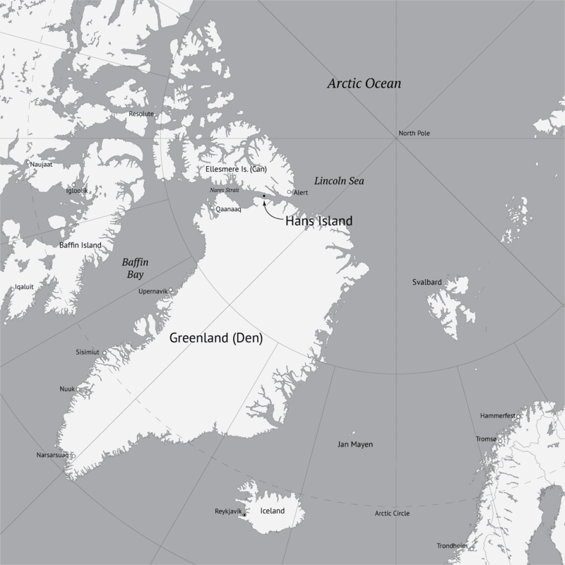
The Whisky War (also known as Liquor wars) is a pseudo-confrontation and border conflict between Denmark and Canada over Hans Island. Since the 1930s, Hans Island has been in the middle of a disagreement between the two nations.
Background
Hans Island is in the middle of the Kennedy Channel between Greenland and Ellesmere Island. A theoretical line in the middle of the strait goes through the island. Canada and Denmark could not come to terms on Hans Island in 1973 when a border treaty was signed, leaving a gap in its border description.
Conflict
In 1984, Canada provoked Denmark by planting its flag on the island and leaving a bottle of Canadian whisky. The Danish Minister of Greenland Affairs came to the island himself the same year with the Danish flag and a bottle of Snaps and a letter stating “Velkommen til den danske ø” (English: ‘Welcome to the Danish Island’).
Resolution efforts
Both countries agreed on a process in 2005 to resolve the issue.
Timeline
1980–1983 – Canadian firm Dome Petroleum did research on and around the island.
1984 – Tom Høyem, Danish Minister for Greenland, chartered a helicopter to the island, placing a flag and a bottle there.
1988 – The Danish Arctic Ocean patrol cutter HDMS Tulugaq arrived at the island, built a cairn and placed a flagpole and Danish flag on the island.
1995 – The Danish liaison officer and geodesists flew in and placed another flagpole and flag. Late August 1997 – The Danish Arctic/Ocean patrol cutter HDMS Agpa tried to reach the island, but was forced to turn around 241 km (150 mi) from the Island, owing to extreme ice.
2001 – Keith Dewing and Chris Harrison, geologists with the Geological Survey of Canada who were mapping northern Ellesmere Island, flew by helicopter to the island.
August 13, 2002 – The Danish inspection ship HDMS Vædderen arrived and erected a new cairn, flagpole and flag, finding the 1988 flag missing and the 1995 flag in pieces.
August 1, 2003 – The crew of the Danish frigate HDMS Triton landed on the island and replaced the Danish flag again.
July 13, 2005 – Canadian soldiers land on the Island, placing a traditional Inuit stone marker (Inukshuk) with a plaque and a Canadian flag.
July 20, 2005 – As a symbolic move, Canadian Defence Minister Bill Graham set foot on the island.
July 25, 2005 – A Danish government official announced Denmark would issue a letter of protest to Canada.
July 25, 2005 – Deputy premier of Greenland, Josef Motzfeldt, stated the island had been occupied by Canada, stating experts should determine which country the island belongs to.
July 28, 2005 – The Danish Ambassador to Canada published an article in the Ottawa Citizen newspaper regarding the Danish view on the Hans Island issue.
August 4, 2005 – The Danish Arctic/Ocean patrol cutter HDMS Tulugaq was sent from Naval Station Grønnedal to Hans Island to assert Danish sovereignty. The cutter was expected to arrive in three weeks’ time.
August 8, 2005 – Danish newspapers reported Canada wished to open negotiations regarding the future of Hans Island. The news was welcomed by Danish Prime Minister Anders Fogh Rasmussen who stated “It is time to stop the flag war. It has no place in a modern, international world. Countries like Denmark and Canada must be able to find a peaceful solution in a case such as this.”
August 16, 2005 – According to Danish Foreign Minister Per Stig Møller, Denmark and Canada agreed to reopen negotiations regarding the future of Hans Island. Denmark would immediately begin geological surveys in the area, and Per Stig Møller would meet his Canadian counterpart Pierre Pettigrew in New York City in the middle of September. Should they fail to reach an agreement, both governments have agreed to submit the dispute to the International Court of Justice in The Hague. The government of Greenland agreed to this course of action. Regarding the Danish patrol cutter HDMS Tulugaq then en route to Hans Island, the minister stated “I have instructed the ship to sail there, but they will not go ashore tearing down [the Canadian] flag and replacing it with a new one. It would be a somewhat childish [behaviour] between two NATO allies.”
August 20, 2005 – Canada’s Foreign Affairs Minister, Pierre Pettigrew, stated Canada’s claim to the island had a firm basis in international law and would likely not end up before a world court. “Our sovereignty over the island has a very strong foundation,” the minister said in a telephone interview with a Canadian Press journalist.
September 19, 2005 – According to Canada’s Foreign Affairs Minister, Pierre Pettigrew, Canada and Denmark have agreed on a process to resolve the dispute over the island. Pettigrew and his Danish counterpart, Per Stig Møller, met in New York on this day. Pettigrew said the two countries would work together “to put this issue behind us.” However Pettigrew reiterated Canada has sovereignty over the island.
August 16, 2006 – A Vancouver geologist receives a prospecting permit for Hans Island from the Canadian government.
March 17, 2007 – Scientists from the University of Toronto and the Technical University of Denmark announced plans to install an automated weather station on the island, some time in the summer of 2007.
July, 2007 – Canada updates satellite photos and recognizes its line constructed for the earlier maritime agreement would have run roughly through the middle of the island; negotiations continue with Denmark over establishing an international land boundary or island sovereignty.
May 4, 2008 – An international group of scientists from Australia, Canada, Denmark, and the UK installed an automated weather station on Hans Island.
April 11, 2012 – Proposal for Canada and Denmark to split Hans Island.
November 29, 2012 – Canada and Denmark settle an agreement on the exact border between them, though without defining the border near Hans Island.
May 23, 2018 – Canada and Denmark announce a Joint Task Force to settle the dispute over Hans Island.
February 2019 – Canadian geologist John Robins is granted a minerals exploration claim for Hans Island by the Canadian government as part of efforts to help the cause of Canada’s sovereignty claim.
September 12, 2019 – The Government of Greenland decided to approve a temporary closure of Hans Island for the application for mineral exploration permits. This approval was based on an agreement between the Government of Canada and the Kingdom of Denmark. The Canadian geologist John Robins therefore also had his minerals exploration claim for Hans Island suspended by the Canadian government. The Dane Andreas G. Jensen also had his application for mineral exploration permit rejected by the Kingdom of Denmark, because of this closure agreement.