


The Hill of Crosses is a site of pilgrimage about 12 km north of the city of Šiauliai, in northern Lithuania. The precise origin of the practice of leaving crosses on the hill is uncertain, but it is believed that the first crosses were placed on the former Jurgaičiai or Domantai hill fort after the 1831 Uprising. Over the generations, not only crosses and crucifixes, but statues of the Virgin Mary, carvings of Lithuanian patriots and thousands of tiny effigies and rosaries have been brought here by Catholic pilgrims. The exact number of crosses is unknown, but estimates put it at about 55,000 in 1990 and 100,000 in 2006.

Over the generations, the place has come to signify the peaceful endurance of Lithuanian Catholicism despite the threats it faced throughout history. After the 3rd partition of the Polish–Lithuanian Commonwealth in 1795, Lithuania became part of the Russian Empire. Poles and Lithuanians unsuccessfully rebelled against Russian authorities in 1831 and 1863. These two uprisings are connected with the beginnings of the hill: as families could not locate bodies of perished rebels, they started putting up symbolic crosses in place of a former hill fort.
When the old political structure of Eastern Europe fell apart in 1918, Lithuania once again declared its independence. Throughout this time, the Hill of Crosses was used as a place for Lithuanians to pray for peace, for their country, and for the loved ones they had lost during the Wars of Independence.
The site took on a special significance during the years 1944–1990, when Lithuania was occupied by the Soviet Union. Continuing to travel to the hill and leave their tributes, Lithuanians used it to demonstrate their allegiance to their original identity, religion and heritage. It was a venue of peaceful resistance, although the Soviets worked hard to remove new crosses, and bulldozed the site at least three times (including attempts in 1963 and 1973). There were even rumors that the authorities planned to build a dam on the nearby Kulvė River, a tributary to Mūša, so that the hill would end up underwater.
On September 7, 1993, Pope John Paul II visited the Hill of Crosses, declaring it a place for hope, peace, love and sacrifice. In 2000 a Franciscan hermitage was opened nearby. The interior decoration draws links with La Verna, the mountain where St. Francis is said to have received his stigmata. The hill remains under nobody’s jurisdiction; therefore people are free to build crosses as they see fit.


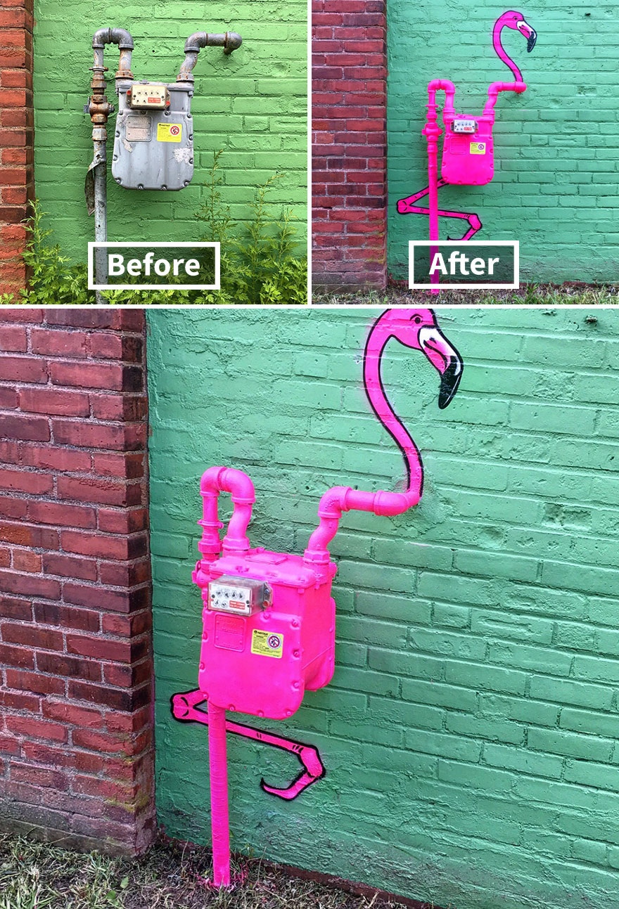
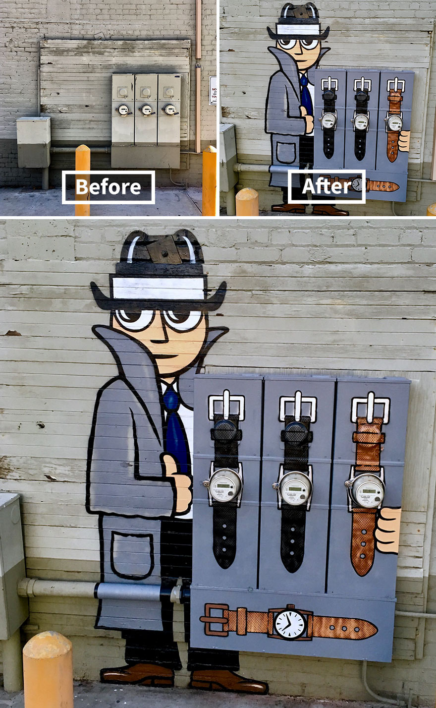
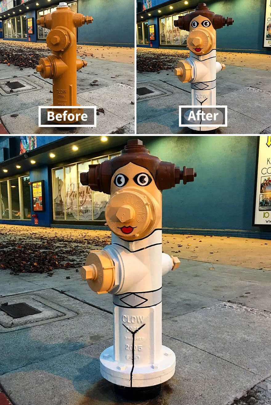
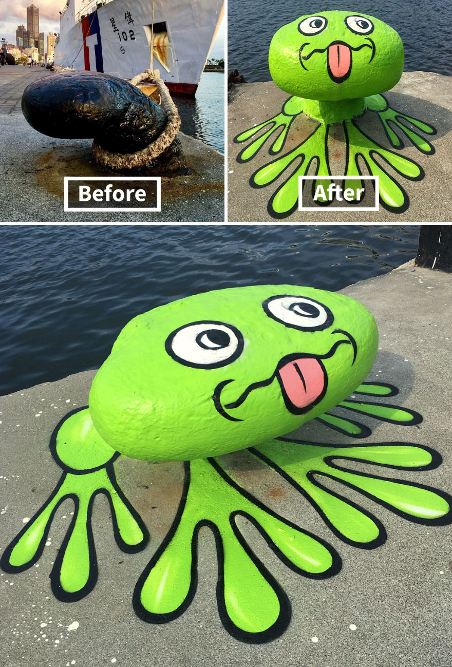
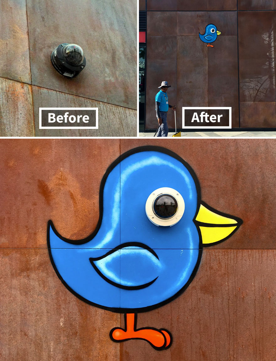
Tom Bob refuses to simply live in the world.
He’s reshaping it. Creating clever street art on common objects in the urban landscape, he’s perfectly personalizing his boring surroundings.
Whether it’s turning a pipe into an anteater or transforming a fire hydrant into Princess Leia, there’s nothing he can’t do.
Usually, Tom Bob operates in NYC, but sometimes he unleashes his creativity elsewhere as well.


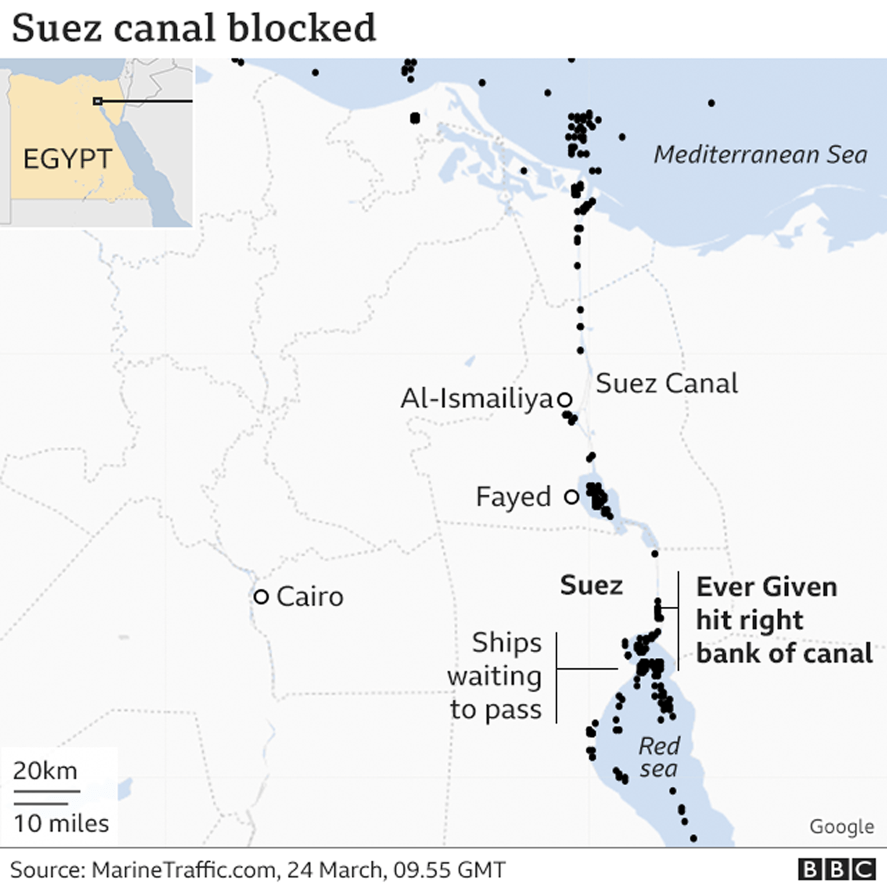
A giant container ship the length of four football pitches has become wedged across Egypt’s Suez Canal, blocking one of the world’s busiest trade routes.
Dozens of vessels are stuck, waiting for rescue boats to free the 400m-long (1,312ft) ship, which was knocked off course by strong winds.
Egypt has reopened the canal’s older channel to divert some traffic until the grounded ship can move again.
The blockage sent oil prices climbing on international markets.
About 12% of global trade passes through the Suez Canal, which connects the Mediterranean to the Red Sea and provides the shortest sea link between Asia and Europe.
The Ever Given, registered in Panama and operated by the shipping company Evergreen, was bound for the port city of Rotterdam in the Netherlands from China and was passing northwards through the canal on its way to the Mediterranean.

The 200,000 tonne ship, built in 2018 and operated by Taiwanese transport company Evergreen Marine, ran aground and became lodged sideways across the waterway at about 07:40 local time (05:40 GMT) on Tuesday.
At 400m long and 59m wide, the ship has blocked the path of other vessels which are now trapped in lines in both directions.
The company that manages the container ship, Bernhard Schulte Shipmanagement (BSM), has denied earlier reports that the ship had already been partially refloated.

A daring drone photographer in Iceland captured breathtaking footage of an unfolding volcanic eruption by flying his UAV over the top of the active crater as lava burst forth high into the air. The amazing footage was reportedly filmed by Bjorn Steinbekk last Friday as the Fagradalsfjall volcano sprung to life following a series of small earthquakes in the country. Sensing the opportunity to document the event from a truly unique perspective, the visual artist fired up his drone and did just that, capturing several stunning overhead scenes of the eruption.
In one of Steinbekk’s videos, seen above, the drone cruises along a long river of lava flowing from the volcano and, amazingly, when it reaches the active crater, the UAV continues onward over the top of the eruption as it is happening. Either by way of sheer luck or skillful maneuvering, the vehicle manages to deftly avoid the molten rock as it spews forth from the site. “I really thought I would never see my drone again,” Steinbekk marveled, “but man, this was so thrilling to capture!”

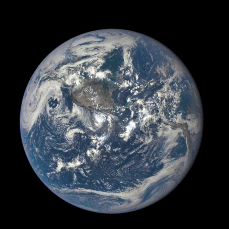
Deep Space Climate Observatory (DSCOVR; formerly known as Triana, unofficially known as GoreSat is a National Oceanic and Atmospheric Administration (NOAA) space weather, space climate, and Earth observation satellite. It was launched by SpaceX on a Falcon 9 v1.1 launch vehicle on 11 February 2015, from Cape Canaveral. This is NOAA’s first operational deep space satellite and became its primary system of warning Earth in the event of solar magnetic storms.
On 6 July 2015, DSCOVR returned its first publicly released view of the entire sunlit side of Earth from 1,475,207 km (916,651 mi) away, taken by the EPIC instrument. The moon is roughly 250,000 miles from earth. EPIC provides a daily series of Earth images, enabling the first-time study of daily variations over the entire globe. The images, available 12 to 36 hours after they are made, have been posted to a dedicated web page since September 2015.
The Moon transiting Earth, 16 July 2015. The far side of the Moon faces the camera.