The Pink Lake of Australia

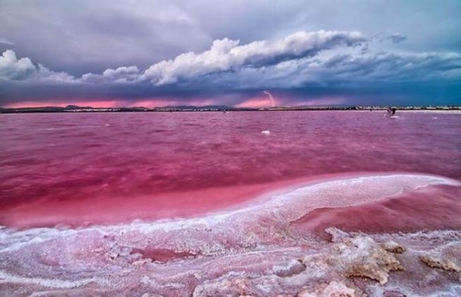
Lake Hillier is a saline lake on the edge of Middle Island, the largest of the islands and islets that make up the Recherche Archipelago in the Goldfields-Esperance region, off the south coast of Western Australia. It is particularly notable for its pink colour. A long and thin shore divides the Southern Ocean from the lake.

Lake-Hillier-Landscape

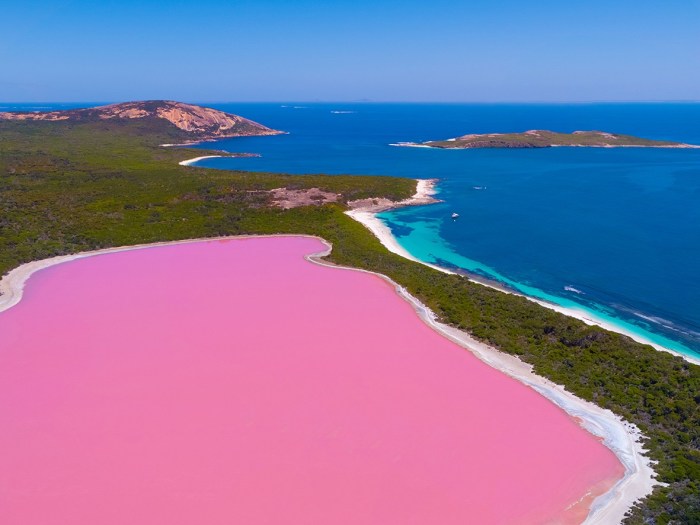
Lake Hillier is about 600 metres (2,000 ft) in length by about 250 m (820 ft) in width. The lake is surrounded by a rim of sand and a dense woodland of paperbark and eucalyptus trees with a narrow strip of sand dunes covered by vegetation separating its northern edge from the northern coast of Middle Island. The most notable feature of the lake is its pink colour. The vibrant colour is permanent, and does not alter when the water is taken in a container. The pink colour is considered to be due to the presence of the organism Dunaliella salina. Air is the best mode of transportation for viewing the lake. At one point in its history the lake was used to collect salt.

lake1

Lake Hillier was visited by the Matthew Flinders’ expedition on 15 January 1802. Flinders’ journal entries are considered to be the first written records of the lake. Flinders observed the pink lake after ascending the island’s highest peak (now called Flinders Peak), describing the lake as follows:

In the north-eastern part was a small lake of a rose colour, the water of which, as I was informed by Mr. Thistle who visited it, was so saturated with salt that sufficient quantities were crystallised near the shores to load a ship. The specimen he brought on board was of a good quality, and required no other process than drying to be fit for use.

Flinders visited Middle Island again in May 1803; he intended “to stop a day or two in Goose-Island Bay, for the purposes of procuring geese for our sick people, seal oil for our lamps, and a few casks of salt from the lake on Middle Island”. It is reported that Flinders subsequently named the lake after William Hillier, a crew member of Investigator who died of dysentery on 20 May 1803 prior to the expedition’s departure from Middle Island.

In 1889, Edward Andrews investigated the commercial possibilities of producing salt from Lake Hillier, and briefly moved onto the island with both of his sons. They left after working the salt deposits for about one year.

The lake was subject to salt mining during the late 19th century. The salt mining enterprise is reported as failing for a number of reasons including “the toxicity of the salt collected for consumption”.

lake2

lake4

The only living organisms in Lake Hillier are microorganisms including Dunaliella salina, which causes the salt content in the lake to create a red dye which helps produce the colour, as well as red halophilic bacteria present in the salt crusts. Despite the unusual hue, the lake exhibits no known adverse effects upon humans. From above, the lake appears a solid bubble gum pink, but from the shoreline it appears more of a clear pink hue. The shoreline is also covered in salt crust deposits.

Despite the high salt content levels (comparable to those of the Dead Sea), Lake Hillier is safe to swim in. However, there are very few ways to reach Lake Hillier. Aeroplane scenic flights are the most common method, with 6 flights a day departing Esperance Airport, flying over Lake Hillier via the nearby Cape Le Grand National Park. Cruises are also an option for passengers wanting to visit the isolated lake, and surrounding forest area.

lakeLAGO-HILLIER-2

lake3

Lake-Hillier-Voucher


Penguin ‘Supercolony’ Found in Antarctica

Time

Scientists have discovered a previously unknown “supercolony” of more than 1.5 million rare penguins on an island located off the Antarctic Peninsula. The researchers from Stony Brook University discovered the enormous colony of Adelie Penguins after analyzing satellite imagery of the island. The population of Adelie Penguins had been previously thought to be in decline.

The Flying Saucer Clouds

dog10

Lenticular clouds (Altocumulus lenticularis in Latin) are stationary clouds that form in the troposphere, typically in perpendicular alignment to the wind direction. They are often comparable in appearance to a lens or saucer.

Because of their unique appearance, they have been brought forward as an explanation for some unidentified flying object (UFO) sightings.

feb 4a

Fantastisch Wasserfällen

Water and gravity = Fantastisch Wasserfällen


awater 7 sisters norway

Seven Sisters Waterfall Norway


awater Baatara Gorge Waterfall, Lebanon

Baatara Gorge Waterfall Lebanon


awater dettifoss iceland prometheus

Dettifoss Waterfall Iceland, yes this is the one from the movie Prometheus.


awater dietan china vietnam

Dietan Waterfall, on the border of China and Vietnam


awater grand canyon

Paradise in the Grand Canyon, USA


awater greenland

Glacial waterfall in Greenland


awater hawaii

Waterfall and isolated beach in Hawaii


awater iceland

Iceland


awater letchworth state park ny

Train bridge over a waterfall in Letchworth State Park, New York


awater Migus mill North Carolina

Migus Mill North Carolina. An aqueduct was built to power a corn mill.


awater nepal

Nepal


awater norway

Norway


awater pearl waterfall china

Pearl Waterfall, China


awater romania

Strange moss waterfall in Romania


awater Seljalandsfoss Waterfall, Iceland

Seljalandsfoss Waterfall, Iceland


awater tibet

Tibet


awater waterfall of the gods iceland

Waterfall of the Gods, Iceland


awater zion np utah

Zion National Park, Utah


Ten Cities Dangerously Situated in Earthquake Zones

I’m glad I live in Manitoba.  I dislike blizzards and -30 wind chill.  But at least I don’t have to live with the threat of my apartment building shaking and collapsing from under me.

Photo from Chile:

These are the top ten cities in the world that face the most serious threat from earthquakes.

San Francisco

More than any other U.S. city, San Francisco is known for major earthquakes, most famously the 1906 quake that caused a fire that destroyed much of the city. Later research into the earthquake led to the discovery of the San Andreas Fault. Frisco remains at high risk for a big one: Between now and 2032, there’s a 62 percent chance of a quake stronger than 6.6 on the Richter scale.

Istanbul

Situated on the North Anatolian fault line—one of the most active in the world—Istanbul has been on earthquake watch for years and is what The Guardian once called “a disaster waiting to happen.” With 15 million residents and 1.6 million buildings, Istanbul is a difficult city to prepare for this kind of disaster, but recently officials have tightened regulations on buildings, and the World Bank has donated millions to aid in preparatory measures. Studies by the U.S. Geological Survey found as much as a 70 percent chance of a major earthquake in the city within the next three decades.

Tokyo

The Great Kanto Quake that rocked Tokyo in 1923 still ranks as one of the world’s worst disasters of the 20th century. Fires spread across the city and took two days to extinguish because the quake had ruptured water lines. Scientists think there’s a 70 percent chance that in the coming decades another big earthquake will wreak havoc the capital of Japan—the most quake-prone country in the world.

Los Angeles

Los Angeles also contains nearly 100 faults, and is one of the major cities along the San Andreas Fault Zone, which moves two inches per year. The most recent significant earthquake in L.A.’s history occurred in 1994, was 6.7 in magnitude, and was “the costliest U.S. earthquake since 1906.” The city is expected to experience at least one earthquake a year of magnitude 5.0 or greater, scientists say.

Tehran

Scientists estimate that a major earthquake could kill as many as a million people in Tehran, making it one of the most vulnerable cities to an earthquake in the world. Home to 8.5 million inhabitants and an unstable government, the metropolis lies on at least a hundred different fault lines, such a dangerous location that some have argued that Iran should pack up and move its entire capital city to a safer spot.

Manilla

A recent study found that Manila is at greater risk for an earthquake than was previously thought, and last year, a U.N. official made his concern apparent. “You’re gonna have 16,000 buildings destroyed. You’re gonna have…150,000 who are injured,” the head of the U.N.’s Emergency Services Branch told the BBC, predicting an imminent quake of between 7.0 and 8.0 magnitude in this city of 18 million. A colleague echoed his concern.“The big earthquake is certainly coming. The question is when? No one can tell. It can happen today, tomorrow, or next year. But certainly there will be an earthquake.

Mexico City

Haiti’s recent earthquake drew many comparisons to the one that struck Mexico City in 1985. The massive metropolitan area is home to over 21 million people, and the city itself was built on a dried-up lake bed, making the ground underneath like “a huge bowl of gelatin,” according to one researcher. Ominously, on the Earthquake Disaster Risk Index, Mexico City sits just higher than Santiago, Chile.

Quito

Geohazards International conducted an exhaustive study of what would happen to Ecuador’s capital city in the days and weeks following a major earthquake. It predicted severe structural damage due to the “vulnerable adobe” buildings, landslides that bury people and render roads impassable, a breakdown of the city’s water supply, sewage flooding the streets, and thousands of homeless people dying of exposure in the first night after the quake. “Human casualties would be substantial,” the hypothetical scenario states.

Anchorage

The Alaska Seismic Hazards Safety Commission says the 49th state is one of the most earthquake-prone areas in the world, and its largest city gets hit by a moderate tremor most years. The last one to do major damage was on Good Friday in 1964, and, at 9.2 on the Richter scale, it remains the strongest to afflict North America to date. Since then, Alaska’s population has more than doubled, and the Federal Emergency Management Agency estimates that “with the present infrastructure and policies, Alaska will have the second highest… earthquake-loss ratio in the country.”

Kathmandu

This Nepalese city is especially vulnerable thanks to its haphazardly constructed homes built with reinforced concrete and filled in with masonry. Experts have warned for years about Kathmandu’s lack of earthquake preparation, the danger intensified by its dense population. The last major quake happened in 1934, when nearly 17,000 city residents died in a minute