The name of the province known as Newfoundland and Labrador is just way too long

Labrador is the distinct northerly region of the Canadian province of Newfoundland and Labrador. It comprises the mainland portion of the province, separated from the island of Newfoundland by the Strait of Belle Isle. It is the largest and northernmost geographical region in Atlantic Canada.

newfoundland-and-labrador-location-on-the-canada-map

Though Labrador’s area is over twice that of the island of Newfoundland, it has only 8% of the province’s population. Only 27,000 people live in Labrador, yet it has its name included in the official title of the province, Newfoundland and Labrador. The two names must be included in the title or one would be committing political correctness sacrilege. All the media and politicians have to say both names. No getting around it.

newfie

This long version of the name is a relatively recent phenomenon. It seems to have started around 10-15 years ago. Why this occurred is clearly blatant political correctness gone wild. Before this long name was introduced it was perfectly fine to call the province just Newfoundland. This double name is like calling Florida, Florida and Panhandle. Totally absurd.

So I have come up with a solution. The map below shows how I would name the province. Hopefully the politicians become aware of the name and implement it pronto.

brador

Funny Place Names of Saskatchewan and Newfoundland

There are many funny place names in Canada. Flin Flon, Optic Lake and Wampum in Manitoba; Hungerford, Pain Court and Zigzag in Ontario; Aachikaayusaakaasich Portage in Quebec, Blubber Bay in B.C., Dead Man’s Flats in Alberta, Nuttby in Nova Scotia, Poodles Corner in P.E.I. and Snafu Creek in the Yukon Territory.
But the two provinces in Canada with the nuttiest names have to be Saskatchewan and Newfoundland. As the lists below demonstrate.

big4

big2

SASKATCHEWAN 

Amsterdam –  Antelope – Baldwinton –  Big Beaver –  Biggar –  Blumenheim – B-Say-Tah – Buffalo Narrows  – Cadillac –  Candle Lake – Carrot River  – Ceylon – Chicken – Choiceland – Climax – Congress –  Cut Knife – Druid-  Earl Grey –  Ebenezer – Edelman Lake –  Elbow –  Endeavour –  Eyebrow  – Foam Lake  – Frontier –  Grandmother’s Bay –  Grizzly Bear’s Head & The Lean Man –  Hague –  Hitchcock –  Holdfast –  Hoosier –  Imperial –  Knee Lake –  Liberty –  Limerick –  Lipton –  Little Bone –  Loon Lake –  Love –  Lucky Lake –  Lucky Man –  Major –  Mantario- Milestone –  Moose Jaw –  Mozart –  Old Wives Lake –  Onion Lake –  Oxbow –  Pennant –  Piapot –  Poor Man –  Porcupine Plain –  Quill Lake –  Revenue –  Reward –  Sanctuary –  Semans –  Smuts –  Spy Hill –  Stockholm –  Swift Current –  Uranium City –  Urin – Xena –  Yellow Grass –  Zip Lake

big

NEWFOUNDLAND

Ass Hill –  Ass Rock –  Back Cove –  Bacon Cove –  Badger –  Bar Haven –  Bareneed –  Bay Bulls –  Billy Butts Pond –  Blow Me Down –  Bottle Cove –  Butter Cove –  Cape Onion –  Catalina –  Change Islands –  Chapel Arm –  Coffee Cove –  Come-By-Chance –  Comfort Cove –  Conception Bay –  Cow Head –  Cupids –  Curling –  Deadman’s Bay –  Deadman’s Cove –  Diamond Cove –  Dildo –  Exploits River –  Ferryland –  Fleur de Lys –  Flowers Cove –  Fortune –  Fox Roost –  Foxtrap –  Frenchman’s Cove –  Funk Lake –  Furby’s Cove –  Gander –  Gin Cove –  Goblin –  Goobies –  Halfway Point –  Happy Adventure –  Happy Valley – Goose Bay –  Hare Bay –  Hatchet Cove –  Hearts Content –  Hearts Delight –  Heart’s Desire –  Jerrys Nose –  Lawn –  Leading Tickles West –  Little Seldom –  Low Point –  Mosquito –  Mouse Island –  Nameless Cove –  New World Island –  Nippers Harbour –  Noggin Cove –  Old Man’s Head –  Old Room –  Paradise –  Pasadena –  Penetanguishene –  Petty Harbour –  Poor Boy Island –  Quidi Vidi Harbour –  Red Indian Lake –  River of Ponds –  Salvage –  Seldom –  Small Point –  St. Jones Within –  St. Jones Without –  Stag Harbour –  Tickle Cove –  Toogood Arm –  Virgin Arm –  Wild Bight –  Wreck Cove

big3

big1

Just for the record, I forgot Skookumchuck in B.C. and Whycocomagh in Nova Scotia.

Hawaii from Space

hawaii (2)

hawaii (3)

hawaii (4)

hawaii (1)

Hawaii – Wikipedia

Area Ranked 43rd
 • Total 10,931 sq mi
(28,311 km2)
 • Width n/a miles (n/a km)
 • Length 1,522 miles (2,450 km)
 • % water 41.2
 • Latitude 18° 55′ N to 28° 27′ N
 • Longitude 154° 48′ W to 178° 22′ W
Population Ranked 40th
 • Total 1,431,603 (2015 est)
 • Density 214/sq mi  (82.6/km2)

hawaiian-islands-taken-from-the-space-shuttle-stocktrek

hawaii1

The Big Island

hawaii2

Oahu

National Geographic Photos of the Week

ng india adaman islands

Andaman Islands in the Bay of Bengal

ng1 alaska

Alaska

ng2 Rwanda

Silverback gorilla in Rwanda

ng3 hawaii

Volcano in Hawaii

ng4 mexico city

Mexico City

ng5 yosemite

Yosemite, California

ng6 seoul

Plaza in Seoul, South Korea

ng7 n california

Sequoias in northern California

ng8 peru

Peru roundup

ng9 finland

Finland spa

ng10 st. peter's square

Vatican

ng11 nepal

Village in Nepal

ng12 india

Playing polo in India

ng13 grand canyon

Grand Canyon

ng14 pennsylvania

They still do this, and it isn’t England. This is Pennsylvania!

ng20

Horse skiing in Colorado

ng15 denmark

Denmark

ng16 china tibet frontier

China near the Tibetan frontier

Shark attack in Australia

shark1

I kid, B-movie scene.

Real Life Waterworld City

Malé (pronounced Mali) is the capital and most populous city in the Republic of Maldives. With a population of 133,412[1] and an area of 5.8 square kilometres (2.2 sq mi), it is also one of the most densely populated cities in the world.[2] The city is geographically located at the southern edge of North Malé Atoll (Kaafu Atoll).[3] Administratively, the city consists of a central island, an airport island, and two other islands governed by the Malé City Council.

Male-total

Country Maldives
Geographic atoll North Male Atoll
Government
 • Council Malé City Council
 • Mayor Mohammed Shihab
Area
 • Total 5.8 km2 (2.2 sq mi)
Elevation 2.4 m (7.9 ft)
Population (2014)
 • Total 133,412
 • Density 23,002/km2 (59,570/sq mi)
Time zone MVT (UTC+05:00)

male1

male3

male2

male4

male5

Maldives-Male

No, this is not Avatar, this is Planet Earth

avat

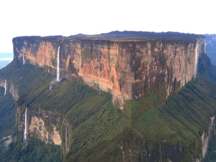
Tepuis are flat table-top mountains found in the Guayana Highlands of South America, especially in Venezuela. In the language of the Pemon people who live in the Gran Sabana, Tepui means ‘House of the Gods’ due to their height.
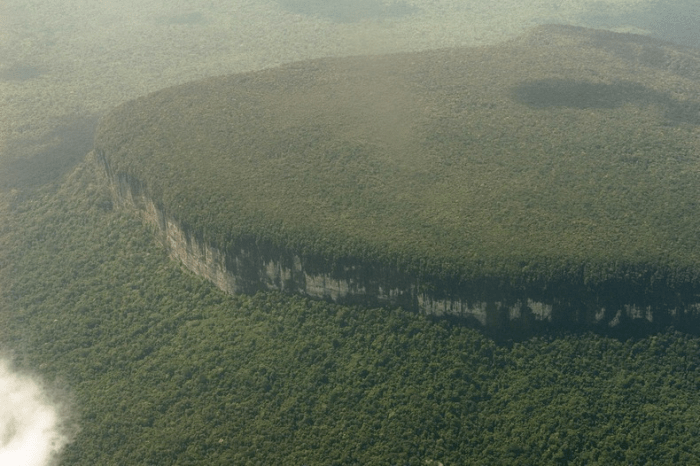
Tepuis tend to be found as isolated entities rather than in connected ranges, which makes them host to hundreds of endemic plant and animal species, some of which are found only on one tepui. Towering over the surrounding forest, the tepuis have almost sheer vertical flanks, and many rise as much as 1,000 meters above the surrounding jungle. The tallest of them are over 3,000 meters tall. The nearly vertical escarpments and dense rainforest bed on which these tepuis or mesa lie make them inaccessible by foot. Only three of the Gran Sabana’s mountains can be reached by foot, among which the 2,180m-high Roraima is the most accessible.

avat1

avat2

Tepuis are the remains of a large sandstone plateau that once covered the granite basement complex between the north border of the Amazon Basin and the Orinoco, between the Atlantic coast and the Rio Negro, during the Precambrian period. Over millions of years, the plateaus were eroded and all that were left were isolated flat-headed tepuis. Although the tepuis looks quite barren, the summit is teeming with life.

The high altitude of tepuis causes them to have a different climate from the ground forest. The top is often cooler with frequent rainfall, while the bases of the mountains have a tropical, warm and humid climate. Many extraordinary plants have adapted to the environment to form species unique to the tepui.
Some 9,400 species of higher plants have been recorded from the Venezuelan Guayana, of which 2322 are registered from the tepuis. Approximately one-third of the species occur nowhere else in the world.
There are 115 such tabletop mountains in the Gran Sabana region in the south-east of Venezuela where the highest concentration of tepuis are found. The most famous among them is Mount Roraima. Roraima, was unexplored until 1884. Today, the plateaued summit is a popular destination for backpackers and home to small waterfalls, natural quartz-lined pools and Punto Triple, the point at which the borders of Venezuela, Brazil and Guyana meet. Mount Roraima is said to have inspired the Scottish author Arthur Conan Doyle to write his novel The Lost World.
The other famous tepui is Auyantepui, home to Angel Falls, the highest waterfall in the world. Auyantepui is also the largest of the tepuis with a surface area of 700 km².

avat3

avat4

avat5

avat6

avat7

The Amazing Twisting Jet Streams

Jet streams are like rivers of wind high above in the atmosphere. These slim strips of strong winds have a huge influence on climate, as they can push air masses around and affect weather patterns.

The jet streams on Earth — other planets have jet streams as well, notably Jupiter and Saturn — typically run from west to east, and their width is relatively narrow compared to their length. Jet streams are typically active at 20,000 feet (6,100 meters) to 50,000 feet (9,144 meters), or about 7 miles (11 kilometers) above the surface and travel in what is known as the troposphere of Earth’s multi-layered atmosphere.

While they are fairly narrow, they cover a wide latitude running north to south and often travel a very winding path; at times they can even fade away or break off into smaller “rivers” of air that merge again “downstream.”
jetstreamconfig
The seasons of the year, location of low and high pressure systems and air temperature all affect when and where a jet stream travels. Jet streams form a border between hot and cold air. Because air temperature influences jet streams, they are more active in the winter when there are wider ranges of temperatures between the competing Arctic and tropic air masses.
Temperature also influences the velocity of the jet stream. The greater the difference in air temperature, the faster the jet stream, which can reach speeds of up to 250 mph (402 kph) or greater, but average about 110 mph (177 kph).
Both the Northern and Southern hemispheres have jet streams, although the jet streams in the north are more forceful. Each hemisphere has two primary jet streams — a polar and a subtropical. The polar jet streams form between the latitudes of 50 and 60 degrees north and south of the equator, and the subtropical jet stream is closer to the equator and takes shape at latitudes of 20 to 30 degrees.
Six day Jet Stream observation ( February 4-9, 2017) by the The Weather Network
jet-stream-feb-8
jet-stream-feb-5
jet-stream-feb-6
jet-stream-feb-7
jet-stream
jet-stream-feb-9
Winnipeg is almost always above the polar jet stream. That’s why we experience the weather below.