The Spanish Cities of North Africa

Unbeknownst to me there are two cities in North Africa that belong to Spain. I discovered this a few days ago. It is European colonization that dates back to the fifteen hundreds. Ceuta and Melilla.

Ceuta is an 18.5-square-kilometre (7.1 sq mi) Spanish autonomous city located on the north coast of Africa, sharing a western border with Morocco. Separated from the Iberian peninsula by the Strait of Gibraltar, Ceuta lies along the boundary between the Mediterranean Sea and the Atlantic Ocean. Ceuta, along with the Spanish exclave Melilla, is one of two permanently inhabited Spanish territories in mainland Africa. It was part of Cádiz province until 14 March 1995 when the city’s Statute of Autonomy was passed.

Ceuta, like Melilla, was a free port before Spain joined the European Union. As of 2011, it has a population of 82,376. Its population consists of Christians, Muslims (chiefly Arabic and Berber speakers), and small minorities of Sephardic Jews and ethnic Sindhi Hindus. Spanish is the official language.

Ceuta

ceuta_desde_el_monte_hacho_2008

Ceuta’s location has made it an important commercial trade and military way-point for many cultures, beginning with the Carthaginians in the 5th century BC, who called the city Abyla; initially, this was also its name in Greek and Latin.  Together with Gibraltar on the European side, it formed one of the famous “Pillars of Hercules”. Later, it was renamed for a formation of seven surrounding smaller mountains, collectively referred to as Septem Fratres (‘[The] Seven Brothers’) by Pomponius Mela, which lent their name to a Roman fortification known as Castellum ad Septem Fratres.

ceuta_melilla

It changed hands again approximately 400 years later, when Vandal tribes ousted the Romans. After being controlled by the Visigoths, it then became an outpost of the Byzantine Empire. Ceuta was an important Christian center since the fourth century (as recent discovered ruins of a Roman basilica show), and consequently is the only place in the Maghreb where the Roman heritage has survived continuously until modern times.

In the 7th century the Umayyads tried to conquer the region but were unsuccessful. Byzantine governor, Julian (described as King of the Ghomara) who was a vassal of the Visigothic kings of Iberia changed his allegiance after the king Roderic raped his daughter, and exhorted the Muslims to invade the Iberian Peninsula. Under the leadership of the Berber general Tariq ibn Ziyad, the Muslims used Ceuta as a staging ground for an assault on Visigothic Iberian Peninsula. After Julian’s death, the Berbers took direct control of the city, which the indigenous Berber tribes resented. They destroyed Ceuta during the Kharijite rebellion led by Maysara al-Matghari in 740.

In 1415, during the Battle of Ceuta, the city was captured by the Portuguese during the reign of John I of Portugal. The Benemerine sultan besieged the city in 1418 but was defeated. Phillip II (King of Spain 1556–1598) ascended the Portuguese throne in 1580 and Spanish kings of Portugal governed Ceuta for 60 years (Iberian Union). During this time, Ceuta attracted many residents of Spanish origin. Ceuta became the only city of the Portuguese Empire that sided with Spain when Portugal regained its independence in 1640, and war broke out between the two countries.

On 1 January 1668 by the Treaty of Lisbon, King Afonso VI of Portugal recognized the formal allegiance of Ceuta to Spain and formally ceded Ceuta to King Carlos II of Spain. However, the original Portuguese flag and coat of arms of Ceuta remained unchanged, and the modern-day Ceuta flag features the configuration of the Portuguese shield. The flag has the same background as that of the flag of the city of Lisbon. The city was besieged by Moroccan forces under Moulay Ismail from 1694 to 1727.

In July 1936, General Francisco Franco took command of the Spanish Army of Africa and rebelled against the Spanish republican government; his military uprising led to the Spanish Civil War of 1936–1939. Franco transported troops to mainland Spain in an airlift using transport aircraft supplied by Germany and Italy. Ceuta became one of the first casualties of the uprising: General Franco’s rebel nationalist forces repressed the citizens of Ceuta, while at the same time the city came under fire from the air and sea forces of the official republican government.

When Spain recognized the independence of Spanish Morocco in 1956, Ceuta and the other plazas de soberanía remained under Spanish rule. Spain considered them integral parts of the Spanish state, but Morocco has disputed this point.

ceuta_spain_crop

ceuta_en

The official currency of Ceuta is the euro. It is part of a special low tax zone in Spain. Ceuta is one of two Spanish port cities on the northern shore of Africa, along with Melilla. They are historically military strongholds, free ports, oil ports, and also fishing ports. Today the economy of the city depends heavily on its port (now in expansion) and its industrial and retail centres. Ceuta Heliport is now used to connect the city to mainland Spain by air.

costa_de_ceuta_espana_2015-12-10_dd_24


Melilla

Melilla is a Spanish autonomous city located on the north coast of Africa, sharing a border with Morocco with an area of 12.3 square kilometres (4.7 sq mi). Melilla, along with Ceuta, is one of two permanently inhabited Spanish cities in mainland Africa. It was part of Málaga province until 14 March 1995 when the city’s Statute of Autonomy was passed.

Melilla, like Ceuta, was a free port before Spain joined the European Union. As of 2011, it had a population of 78,476 made up of ethnic Spaniards, ethnic Riffian Berbers, and a small number of Sephardic Jews and Sindhi Hindus. Both Spanish and Riffian-Berber are the two most widely spoken languages, with Spanish as the only official language.

Melilla is officially claimed by Morocco, which considers it “occupied territory”.

melilla-locator-map

The current Berber name of Melilla is Mřič or Mlilt which means the “white one”. Melilla was an ancient Berber village and a Phoenician and later Punic trade establishment under the name of Rusadir.  Rusaddir was supposed to have once been the seat of a bishop, but there is no record of any bishop of the supposed see, which is not included in the Catholic Church’s list of titular sees. As centuries passed, it went through Vandal, Byzantine and Hispano-Visigothic hands. The political history is similar to that of towns in the region of the Moroccan Rif and southern Spain. Local rule passed through Amazigh, Phoenician, Punic, Roman, Umayyad, Idrisid, Almoravid, Almohad, Marinid, and then Wattasid rulers. During the Middle Ages it was the Berber city of Mlila. It was part of the Kingdom of Fez when the Catholic Monarchs, Queen Isabella I of Castile and King Ferdinand II of Aragon requested Juan Alfonso Pérez de Guzmán, 3rd Duke of Medina Sidonia, to take the city.

In the Conquest of Melilla, the duke sent Pedro Estopiñán, who conquered the city virtually without a fight in 1497, a few years after Castile had taken control of the Nasrid Kingdom of Granada, the last remnant of Al-Andalus, in 1492. Melilla was immediately threatened with reconquest and was besieged during 1694–1696 and 1774–1775. One Spanish officer reflected, “an hour in Melilla, from the point of view of merit, was worth more than thirty years of service to Spain.”

The current limits of the Spanish territory around the fortress were fixed by treaties with Morocco in 1859, 1860, 1861, and 1894. In the late 19th century, as Spanish influence expanded, Melilla became the only authorized center of trade on the Rif coast between Tetuan and the Algerian frontier. The value of trade increased, goat skins, eggs and beeswax being the principal exports, and cotton goods, tea, sugar, and candles being the chief imports.

melilla1

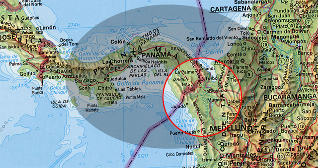
The government of Morocco has requested from Spain the sovereignty of Ceuta and Melilla, of Perejil Island, and of some other small territories. The Spanish position is that both Ceuta and Melilla are integral parts of the Spanish state, and have been since the 15th century. Morocco denies these claims and maintains that the Spanish presence on or near its coast is a remnant of the colonial past which should be ended. The United Nations list of Non-Self-Governing Territories does not include these Spanish territories.

The principal industry is fishing. Cross-border commerce (legal or smuggled) and Spanish and European grants and wages are the other income sources.

Melilla is regularly connected to the Iberian peninsula by air and sea traffic and is also economically connected to Morocco: most of its fruits and vegetables are imported across the border. Moroccans in the city’s hinterland are attracted to it: 36,000 Moroccans cross the border daily to work, shop, or trade goods. The port of Melilla offers several daily connections to Almeria and Málaga. Melilla Airport offers daily flights to Almería, Málaga and Madrid. Spanish operator Air Europa uses nearby Nador International Airport for their connections to mainland Spain.

Many people traveling between Europe and Morocco use the ferry links to Melilla, both for passengers and for freight. Because of this, the port and related companies form an important economic driver for the city.

fence

The Melilla border fence aims to stop illegal immigration into Spain.

melilla

Spanish territories of North Africa

ceuta2

ceuta1

Stunning Hawaiian Beach used in the 1976 King Kong Film

Honopū Valley is a landmark valley within Nā Pali Coast State Park along the northwest shore of Kauai, Hawaii. It is known for its distinctive natural arch, which at approximately 90 feet (27 m) tall is the tallest in Hawaii. At the lower end of the valley is Honopū’s secluded, 0.25-mile (0.40 km) beach, also known as Cathedral Beach.

Honopū means “conch shell”, and the valley’s name is derived from the conch shell-like sound its arch makes when hit by winds from the north.

kong

In the 1976 remake of King Kong the beaches and jungles of Kauai, Hawaii were made to stand in for the South Pacific. Originally only the jungle scenes were to be shot in Hawaii and the rest on Zuma Beach, California. Producer Dino De Laurentiis, however, was so pleased with Hawaii that he decided to film all the beach scenes at Honopū and Kalalau Valley.

kong1

kong2

kong3

kong4

This really does look like an island that would be King Kong territory.

kong5


The Deepest Cave in the World

cave1

Krubera Cave is the deepest-known cave on Earth. It is located in the Arabika Massif of the Gagra Range of the Western Caucasus, in the Gagra district of Abkhazia, a breakaway region of Georgia.
The difference in elevation of the cave’s entrance and its deepest explored point is 2,197 ± 20 metres (7,208 ± 66 ft). It became the deepest-known cave in the world in 2001 when the expedition of the Ukrainian Speleological Association reached a depth of 1,710 m (5,610 ft) which exceeded the depth of the previous deepest-known cave, Lamprechtsofen, in the Austrian Alps, by 80 metres (260 ft). In 2004, for the first time in the history of speleology, the Ukrainian Speleological Association expedition reached a depth greater than 2,000 metres (6,600 ft), and explored the cave to −2,080 m (−6,824 ft). Ukrainian diver Gennadiy Samokhin extended the cave by diving in the terminal sump to 46 metres’ depth in 2007 and then to 52 m in 2012, setting successive world records of 2,191 m and 2,197 m, respectively. Krubera remains the only known cave on Earth deeper than 2,000 metres.

cave

cave2

cave7

cave3

cave8

cave6

cave9

cave4


Prometheus Film Included Stunning Landscapes of Iceland

Exterior shots of the alien world were shot in Iceland, where filming occurred for two weeks. It commenced on July 11, 2011, at the base of Hekla, an active volcano in southern Iceland. Speaking about working at the volcano, Scott said, “If one is afraid of nature in this profession then it would be best to find a different job”. Filming also took place at Dettifoss, one of the most powerful waterfalls in Europe.

Scott said that the filming in Iceland comprised approximately fifteen minutes of footage for the film, and that the area represented the beginning of time. Morocco had been chosen as a location for these scenes, but the 2010 Arab Spring protests forced the change of venue. Alternatives including the Mojave Desert had been considered, but Scott explained that Iceland was ultimately chosen because “here it is so rough and ‘Jurassic-like’ and that proved decisive”.

Dettifoss Waterfall used in the opening scene

pprometheus dettifloss

From the film, an ‘Engineer’ on the edge of the Falls.

prometheus1

prometheus2

Aerial shot from an early sequence in the film

prometheus-img05

This background landscape is actually Jordan. I had to include it because it is so cool. Other geographical locations included Scotland and Spain.

Amazing Iceland landscapes

promo

promo1

promo2

promo3

promo4

promo5

Northern Lights

promo6

Seclusion

promo7

promo8

promo9

promo10

The Forgotten Ruins of Mrauk U

Spread across the beautiful rolling hills of Rakhine in Western Burma, lies a little known archeological site—the medieval town of Mrauk U. Once the capital of the powerful Arakan empire where Portuguese, Dutch and French traders rubbed shoulders with the scholars of Bengal and Mughal princes on the run, Mrauk U is now a sleepy village where goat herders tend to their animals, farmers work their fields and women fetch water from the wells located among the hundreds of old temples and Buddhist pagodas that the Kings of Mrauk U erected during the city’s heydays.

mrauk-u-10

The Mrauk U Kingdom was founded in 1430 by King Min Saw Mon, and Mrauk U remained the capital for more than three hundred and fifty years, until 1785. At its peak, Mrauk U controlled half of Bangladesh and the western part of Lower Burma. Its fame spread to far Europe where it became known as a city of oriental splendor after the Portuguese missionary and traveler, Fray Sebastien Manrique, published a vivid account of the coronation of King Thiri Thudhamma in 1635 and about the Rakhine Court.

As the city grew, the King and the rich inhabitants built many Buddhist pagodas and temples. Some are still being used as places of worship, and these are the main attraction of Mrauk-U. In fact, Mrauk U’s rich collection of temples and pagodas is second only to Bagan, but unlike Bagan, Mrauk U isn’t swarmed with tourists. This is because the place is not easy to reach. There’s no airport, and the only way to get there is by a boat, which takes about 7 to 8 hours.

One thing that sets Mrauk U apart from other popular archeological sites is the local life here that runs right in the heart of this historical site.

Travel writer Robert Reid describes his visit to Mrauk U in a BBC article:

Here, the ruins are merely a backdrop to everyday life. Streams of young women fill tin pots at temple-side wells and take short cuts over cracked pagoda steps to farms sandwiched between 500-year-old stupas. Elders crouch below trees, amid smoking refuse piles and goat herds.

Another difference between Bagan and Mrauk U is that unlike in Bagan, none of the temples in Mrauk U are closed, and can be explored inside out. Although there are far more temples in Bagan than in Mrauk U, the views from the surrounding hills are no less breathtaking. The temples are also different to those in Bagan, made of hewn stone bricks rather than mud and brick. Some of the temples were built like bunkers with thick solid walls, and were probably used as places of refuge during times of war.

Being the former capital of the Arakan empire, Mrauk U was surrounded by long defensive walls and moats, at the center of which stood the Royal Palace. Very little of the palace remains today.

mrauk-u-1

mrauk-u-2

mrauk-u-3

mrauk-u-4

mrauk-u-5

mrauk-u-6

mrauk-u-14

mrauk-u-7

mrauk-u-9

mrauk-u-11

Amusing Planet

Shibam: the Manhattan of the Desert

The city of Shibam, located in the central-western area of Hadhramaut Governorate, Yemen, in the Ramlat al-Sab`atayn desert, is best known for its towering mudbrick skyscrapers. This small town of 7000 is packed with around 500 mud houses standing between 5 and 11 stories tall and reaching 100 feet high, all constructed entirely of mud bricks. The bizarre skyline that the high rise buildings bestow upon the city has earned Shibam the moniker “Manhattan of the Desert.”

Shibam is often called “the oldest skyscraper city in the world” and is one of the oldest and best examples of urban planning based on the principle of vertical construction. Its plan is trapezoidal, almost rectangular; and it is enclosed by earthen walls within which a block of dwellings, also built from earth, have been laid out on an orthogonal grid. Shibam was founded in the 3rd century AD, but most of the houses you see here dates only to the 16th century, following a devastating flood of which Shibam was the victim in 1532-33. However, some older houses and large buildings still remain from the first centuries of Islam, such as the Friday Mosque, built in 904, and the castle, built in 1220.


In general the windowless lower floors are used for grain storage, with areas for domestic use above and those for family and leisure above that. The main room on the second floor is used by men for socializing. It often has wonderful carved plasterwork and freestanding decorated wooden columns supporting the ceiling, while women’s areas are found higher, usually on the third or fourth floor. The highest rooms are for communal use by the whole family, and on the upper levels there are often bridges and doors connecting the houses. These are a defensive feature, but also a practical one – especially for old people who find it difficult to walk up and down the interminable staircases.

The houses needed to be rebuilt over the centuries. Rain and erosion have been constant threats to the buildings here. To protect their homes, residents must thickly coat the facades and roofs with sealant, and ensure they are maintained and regularly renovated. Those who can afford it limewash their houses to protect them against termites.

Shibam was added to UNESCO’s World Heritage list in 1982.


Pittsburgh: the city of hills

Being from Winnipeg, one of the flattest cities in the world, hilly cities have always intrigued me. I always thought San Francisco was the U.S. city with the most hills, but I discovered that Pittsburgh is even hillier than the California city.

The city of Pittsburgh in Pennsylvania, the United States, is located over an unruly terrain of hills, hollows, valleys and three intersecting rivers. Back in the late 19th and early 20th century, when Pittsburgh was growing as a coal and steel town, factory workers built houses in the hills rising above the flat riverbanks that were lined with factories. In order to commute to work, city officials and residents built staircases along the hillsides, originally of wood and later with concrete that ran up and down throughout the city.

Revered American journalist Ernie Pyle famously wrote about the city in 1937:

Pittsburgh is undoubtedly the cockeyedest city in the United States. Physically, it is absolutely irrational. It must have been laid out by a mountain goat… I’ve flown over it, and driven all around it, and studied maps of it, and I hardly know one end of Pittsburgh from the other… There’s just one balm — people who live here can’t find their way around, either.

pitts

Downtown

pittsburgh-pennsylvania

pitts1

The steps

Many of the city’s neighborhoods are steeply sloped with two-lane roads. More than a quarter of Pittsburgh’s neighborhoods make reference to “hills,” “heights,” or other similar indicators by name.

The city has some 712 sets of outdoor pedestrian stairs with 44,645 treads and 24,090 vertical feet including hundreds of paper streets composed entirely of stairs and many other steep streets with stairs for sidewalks. Many provide vistas of the Pittsburgh area while attracting hikers and fitness walkers.


Population (2013)
 • City 305,841
 • Rank US: 62nd
 • Density 5,540/sq mi (2,140/km2)
 • Urban 1,733,853 (US: 27th)
 • Metro 2,360,867 (US: 22nd)
 • CSA 2,659,937 (US: 20th)
 • GMP $131.3 billion (23rd)

pitts2

pitts3

pitts4

pitts12

pitts5

pitts6

pitts7

pitts8

pitts9

The Impenetrable Darien Gap

The Darién Gap is a break in the Pan-American Highway consisting of a large swath of undeveloped swampland and forest within Panama’s Darién Province in Central America and the northern portion of Colombia’s Chocó Department of South America. It measures just over 160 km (99 mi) long and about 50 km (31 mi) wide. Roadbuilding through this area is expensive, and the environmental toll is steep. Political consensus in favor of road construction has not emerged. Consequently there is no road connection through the Darién Gap connecting North/Central America with South America and it is the missing link of the Pan-American Highway.

The geography of the Darién Gap on the Colombian side is dominated primarily by the river delta of the Atrato River, which creates a flat marshland at least 80 km (50 mi) wide, half of this being swampland. The Serranía del Baudó occupy Colombia’s Pacific coast and extend into Panama. The Panamanian side, in sharp contrast, is a mountainous rainforest, with terrain reaching from 60 m (200 ft) in the valley floors to 1,845 m (6,053 ft) at the tallest peaks (Cerro Tacarcuna).

darien


The Pan-American Highway is a system of roads measuring about 48,000 km (30,000 mi) long that crosses through the entirety of North, Central, and South America, with the sole exception of the Darién Gap. On the South American side, the highway terminates at Turbo, Colombia. On the Panamanian side, the road terminus is the town of Yaviza at. This marks a straight-line separation of about 100 km (60 mi). In between is marshland and forest.

darien PanAmericanHwy

Efforts have been made for decades to remedy this missing link in the Pan-American highway. Planning began in 1971 with the help of United States funding, but this was halted in 1974 after concerns raised by environmentalists. Another effort to build the road began in 1992, but by 1994 a United Nations agency reported that the road, and the subsequent development, would cause extensive environmental damage. There is evidence that the Darién Gap has prevented the spread of diseased cattle into Central and North America, which have not seen foot-and-mouth disease since 1954, and since at least the 1970s this has been a substantial factor in preventing a road link through the Darién Gap. The Embera-Wounaan and Kuna have also expressed concern that the road would bring about the potential erosion of their cultures. The gap has been crossed by adventurers on bicycle, motorbike, all-terrain vehicle, and foot, dealing with jungle, swamp, insects, and other hazards.

This place looks like a mosquito and snake infested hot box.
darien gapxx

Darien_National_Park

darien-gap-01

End of the road, Panama side.

darien1